County Parks
and
City Parks
in
Duval County, Florida
Seach our site below
Baker Point Park 4045 San Juan Avenue
Jacksonville, FL 32210
GPS 30° 16'55.54" N 81° 42'29.42" W
Baker Point Park is directly across San Juan Avenue from Stinson Park. Baker Point offers; shoreline fishing from a bulkhead, other amenities such as playground and fishing pier are at Stinson Park. No restrooms at this location.
Blue Cypress Preserve Park 4012 University Boulevard North
Jacksonville, FL 32277
GPS 30° 22'38.27" N 81° 36'25.21" W
( Entrance to park off University Boulevard North )
GPS 30° 22'26.66" N 81° 37'00.32" W
( Foot of fishing pier )
Go to map of County and City parks in
Duval County with fishing
Hours:
7:00am - 9:00pm
Fees:
None
Blue Cypress Preserve Park is 119 acres in size and offers; Picnic tables, 194 parking spaces, fishing pier extends about 250 feet out over the water, about 10 parking spaces directly at the fishing pier, shade structure at end of pier. The restrooms are near the front of the park.
|
|
|
Castaway Island Preserve 2900 San Pablo Road South
Jacksonville, FL 32224
GPS 30° 17'46.33" N 81° 26'16.00" W
( Entrance to preserve )
NOAA
Castaway Island Preserve offers; Fishing pier, hand launch area for kayaks and canoes, numerous small picnic tables with grills at most and restrooms.


Dutton Island Preserve 793 Dutton Island Road West
Jacksonville, FL 32233
GPS 30° 20'25.08" N 81° 25'33.06" W
( Entrance area )
GPS 30° 20'10.75" N 81° 26'01.86" W
( Hand launch & south fishing pier area )
GPS 30° 20'29.47" N 81° 26'00.51" W
( Foot of the north fishing pier )
Go to map of County and City parks in
Duval County with saltwater fishing
Pier is about 150 feet in length, pier makes a bend and is mainly aligned with the shoreline. This is also considered a viewing pier.
Camping is $25.00 + tax per night and there is a $25.00 security deposit.
About 42 acres
1 Large pavilion and 3 smaller ones
Kayaks / Canoe launch
Picnic areas
Pavilions
Camping areas
9000 feet of nature trails
47 car parking
River View Preserve sits between Dutton Island Preserve and Tide Views Preserve
|
|
|


Helen Cooper Floyd Park 793 Dutton Island Road West
Jacksonville, FL 32233
GPS 30° 22'54.74 N 81° 26'18.17" W
Go to map of County and City parks in
Duval County with saltwater fishing
|
|
|


![]()
Huguenot Memorial Park
10580 Hecksher Drive
Jacksonville, FL 32226
1-904-251-3335
GPS 30° 24'39.07" N 81° 25'20.20" W
( Entrance )
Go to map of County and City parks in
Duval County with fishing
Fees:
$3.00 per vehicle up to six people
Beach Driving: Before 10:00am $1.00 per person
( max of $3.00 )
after 10:00am $3.00 per vehicle up to six people.
4 wheel drive required for beach driving.
Kite surfing is quite popular here.
357 acres
Picnic tables 75
Camping facilities 71
Car parking 91
Be careful not to confuse with Huguenot Park which is also in Jacksonville
|
|
|
Julington ~ Durbin Preserve
13130 Bartram Park Boulevard
Jacksonville, FL 32223
GPS
Go to map of County and City parks in
Duval County with fishing
|
|
|
Kathryn Abbey Hanna Park
500 Wonderwood Drive
Jacksonville, FL 32233
GPS 30° 22'16.62" N 81° 24'33.52" W
( Western side entrance )
GPS 30° 21'59.12" N 81° 23'58.87" W
( Entrance to park from
Seminole Landing Road closer to ocean )
Go to map of County and City parks in
Duval County with saltwater fishing
1-904-249-4700
1-904-247-8688 ( fax )
Fees:
8am - 10am $1.00 per person
10am - closing $3.00 per vehicle up to six occupants ( each additional $1.00 )
$1.00 per motorcycle, pedestrian ( 6 or older ) and bicyclists
446 acres
Picnic tables 190
Camping facilities 293
Car parking 178
Grills 344
Cabins available for rental more information at 1-904-249-4700
|
|
|
Mandarin Park
14780 Mandarin Road
Jacksonville, FL 32223
GPS 30° 08'19.48" N 81° 38'10.68" W
( Entrance )
Memorial Park
1620 Riverside Avenue
Jacksonville, FL 32204
GPS 30° 18'40.87" N 81° 40'46.65" W
Go to map of County and City parks in
Duval County with fishing
|
|
|
Northshore Picnic Park
 7901 North Pearl Street
Jacksonville, FL, 32208
GPS 30° 23'23.36" N 81° 39'23.23" W
Go to map of County and City parks in
Duval County with fishing
|
|
|


Palmetto Leaves Regional Park South Entrance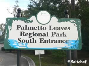 Old St Augustine Road
GPS 30° 08'36.13" N 81° 33'13.07" W
( South entrance off Old St Augustine Road )
Palmetto Leaves Regional Park along Big Davis Creek a short distance from Julington Creek offers; Hand launch, fishing, small picnic pavilion, grill and restrooms.


Reddie Point Preserve 4499 Yachtman Way
Jacksonville, FL 32277
GPS 30° 23'05.22" N 81° 36'57.00" W
( Entrance to Preserve off Yachtsman Way )
GPS 30° 23'21.17" N 81° 37'10.48" W
( Foot of fishing pier )
Go to map of County and City parks in
Duval County with fishing
|
|
|
Rheddie Point Preserve offers; 50 parking spots, 5 handicap spots, hand launch area, fishing pier and Port-O-Lets.
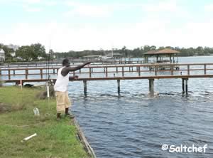
Rotary Park
GPS 30° 17'25.05" N 81° 25'04.44" W
( Entrance )
Rotary Park offers; fishing pier, playground. Portable restrooms are at the boat ramp parking lot.
Signet Park 197 West 67th Street
Jacksonville, FL 32208
GPS
Stinson Park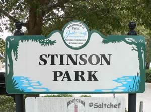 4050 San Juan Avenue
Jacksonville, FL 32210
GPS 30° 16'55.55" N 81° 42'31.81" W
( Entrance off San Juan Avenue )
Go to map of County and City parks in
Duval County with fishing
|
|
|


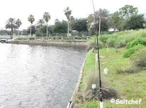
Stockton Park 4021 Ortega Boulevard
Jacksonville, FL 32210
GPS 30° 16'27.96" N 81° 42'02.57" W
( Entrance )
Fishing, benches, drinking fountain, trash receptacles and picnic tables.


Tide Views Preserve 1 Begonia Street
Atlantic Beach, FL 32233
GPS 30° 19'31.39" N 81° 25'26.13" W
( Entrance to Preserve )
Go to map of County and City parks in
Duval County with saltwater fishing
|
|
|
Click here for more info and photos of the fishing pier at Tide Views Preserve.
Useful Links
| County & City Parks with Salt or Brackish Water Fishing near Jacksonville, Florida |
| Areas in Duval County, Florida Include; Atlantic Beach, Arlington, Baldwin, Englewood, Jacksonville, Jacksonville Beach, Mayport, Mandarin, Neptune Beach, Pecan Park and Mayport Naval Station. |
| Bodies of Salt & Brackish Water in Duval County, Florida Include; Arlington River, Atlantic Ocean, Big Pottsburg Creek, Back River, Big Fishweir Creek, Boathouse Creek, Broward River, Browns Creek, Burton Creek, Butcher Pen Creek, Caney Branch, Cedar Creek, Cedar Point Creek, Chicopit Bay, Christopher Creek, Clapboard Creek, Craig Creek, Dames Point Fulton Cutoff, Deep Creek, Deese Creek, Drummond Creek, Dunn Creek, Durbin Creek, Edwards Creek, Fishing Creek, Fitzpatrick Creek, Fort George River, Garden Creek, Goddby's Creek, Gunnison Cut, Hannah Mills Creek, Horseshoe Creek, Intracoastal Waterway, Julington Creek, Little Clapboard Creek, Little Pottsburg Creek, Mill Cove, Mill Creek, Miller Creek, Mink Creek, Moncrief Creek, Mud River, Nassau River, Nassau Sound, Nichols Creek, Ninemile River, Old Bull Bay, Ortega River, Pablo Creek, Plummers Cove, Pottsburg Creek, Pumpkin Hill Creek, Ribault River, Rushing Branch, Samples Creek, San Carlos Creek, Sawpit Creek, Seaton Creek, Shad Creek, Sherman Creek, Simpson Creek, Sisters Creek, St. Johns River, Strawberry Creek, Terrapin Creek, Thomas Creek, Trout River and Williamson Creek. |
![]() Home
Home
![]() About
About
![]() Sitemap
Sitemap
![]() Credits
Credits
![]() Privacy
Privacy
![]() Advertise
Advertise
![]() Contact
Contact
![]()