National Parks
and
State Parks
in
Camden County, Georgia
Seach our site below
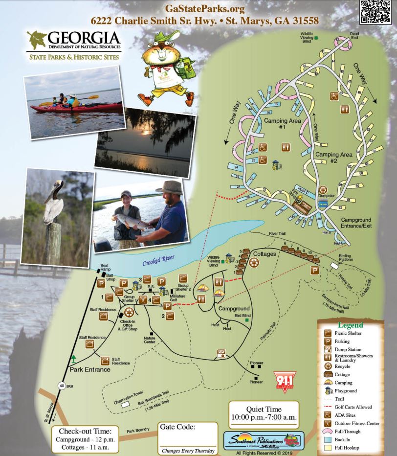
Crooked River State Park 6222 Charlie Smith Sr. Highway
St. Marys, GA 31558
1-912-882-5256
GPS 30° 50' 25.07" N 81° 33' 42.81" W
( Main Entrance )
GPS 30° 50' 43.28" N 81° 33' 35.57" W
( Waters edge at ramp )
NOAA tides ~ Kings Bay, GA Station 8679511
|
|
|
Cumberland Island National Seashore Mainland Ferry Station 113 Saint Marys Street West
St Marys, GA 31558
1-877-860-6787
( Ferry service )
1-912-882-4336
( Cumberland Island National Seashore )
Cumberland Island National Seashore Information
Useful Links
| Georgia Saltwater Fishing Regulations | Safe Handling of Self Caught Seafood |
| Videos of Fishing Knots | Seafood Recipes |
| Fish Species of Atlantic |
| National & State Parks with Salt or Brackish Water Fishing in Camden County, Georgia |
| Areas in Camden County, Georgia include; Colesburg, Halifax, Harrietts Bluff, Hickory Bluff, Kings Bay Submarine Base, Kinlaw, Scotchville, Seals, St Marys, Woodbine, White Oak and Waverly. |
| Bodies of brackish and saltwater in Camden County, Georgia include; Atalntic Ocean, Bailys Cut, Bearskull Creek, Black Point River, Brickhill River, Brockington Creek, Brokehook Creek, Burrells Creek, Catfish Creek, Crooked River, Cumberland River, Cumberland Sound, Dark Entry Creek, Deep Creek, Delaroche Creek, Denver Cut, Dover Creek, Floyd Creek, Gowrie Creek, Gum Branch, Hawkins Creek, Heads Creek, Honey Creek, Kings Bay, Kirby Creek, Little Satilla River, Maiden Creek, Malknitooh Creek, Marianna Creek, Mill Creek, Millers Branch, Mud Creek, Mumford Creek, North River, Noyles Cut, Point Peter Creek, Sadlers Creek, Saint Andrews Sound, Saras Landing Creek, Satilla River, Shelbine Creek, Shell Creek, Sweeney Creek, Todd Creek, Umbrella Creek, Waverly Creek and White Oak Creek, |
![]() Home
Home
![]() About
About
![]() Sitemap
Sitemap
![]() Credits
Credits
![]() Privacy
Privacy
![]() Advertise
Advertise
![]() Contact
Contact
![]()