
Public
Boat Ramps
in
St Lucie County, Florida
Seach our site below
Black Pearl ~ Museum Pointe Boat Ramp 414 Seaway Drive
Fort Pierce, FL 34950
GPS 27° 27'20.49" N 80° 19'30.60" W
( Entrance )
GPS 27° 27'21.47" N 80° 19'23.92" W
( Waters edge at ramp )
|
|
|
Go to map of boat ramps in St Lucie County
The Black Pearl - Museum Pointe boat ramp is suitable for boats 20 feet and under and gives easy access to the Indian River Lagoon for fishing, boating or any other leisure activity. The facility has 2 lane ramp, non-floating courtesy docks, 11 paved parking spots near the ramp and to the north is an open area used for trailer parking also, about 30 additional spots, fish cleaning station and restrooms.
Fishing pier on site also.


Blind Creek Preserve Boat Ramp & Hand Launch Approx 1.9 miles north of the power plant on A1A ( Coastal Highway ) on the southwest side of the Little Mud Creek bridge. Parking is available on opposite side of road also.
Fort Pierce, Florida 34949
GPS 27° 22'37.19" N 80° 15'17.92" W
( Entrance area )
GPS 27° 22'41.34" N 80° 15'20.58" W
( Waters edge at ramp / hand launch on west side )
GPS 27° 22'41.82" N 80° 15'19.20" W
( Waters edge at ramp on east side )
|
|
|
Blind Creek Preserve offers two separate areas for launching of boat and kayaks on either side of South Ocean Drive ( A1A ), the ramp on the east side has a small courtesy dock, parking on both side probably allows for 50+ vehicles depending on how the parking is done. No restrooms at this location.
Fort Pierce City Boat Ramp / Seven Gables / Manatee Ramp
482 North Indian River Drive Fort Pierce, FL 34950
GPS 27° 27'06.43" N 80° 19'22.26" W
( Waters edge at ramp )
|
|
|
Go to map of boat ramps in St Lucie County
Depending on where your from this ramp can be known in several different ways ~ Fort Pierce Public Ramp / Seven Gables Ramp or Manatee Ramp. No fees for parking at this location. Restrooms are available at the Seven Gables House when they are open. This boat ramp affords easy access into the Indian River Lagoon just south of the South Causeway Bridge. Once into the Lagoon you can fish for Snook and Pompano.


Jaycee Park Boat Ramp South Ocean Drive & Melaleuca Drive
Fort Pierce, FL 34949
GPS 27° 27'08.06" N 80° 17'22.03" W
( Waters edge at ramp )
GPS 27° 27'07.43" N 80° 17'08.56" W
( Entrance )
|
|
|
Go to map of boat ramps in St Lucie County
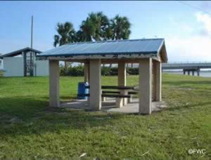
Jaycee Park boat ramp offers; 2 launching lanes, courtesy docks, 12 paved boat trailer parking spaces, many picnic pavilions, large playground and restrooms.


North Causeway Island Boat Ramp and Park 500 North Causeway Drive
Fort Pierce, Florida 34949
1-772-462-2100
GPS 27° 28'25.32" N 80° 19'14.10" W
( Entrance )
GPS 27° 28'25.28" N 80° 19'20.65" W
( Waters ege at ramp )
|
|
|
Go to map of boat ramps in St Lucie County
This park is located on the northern causeway in Fort Pierce, Florida. Amenities and activities at this location include a boat ramp, wash down station, picnic tables, pavilions, fishing, restrooms and canoe or kayak access. This is a pack it out park. Visitors must take all their litter with them.


River Park Marina Boat Ramp 500 East Prima Vista Boulevard
Port St Lucie, FL 34983
GPS 27° 19'23.72" N 80° 19'57.93" W
( Waters edge at ramp )
|
|
|
Go to map of boat ramps in
St Lucie County
The River Park Marina offers; 2 launching lanes, courtesy docks, parking for about 25-30 boat trailers, hand launch for canoes or kayaks, shoreline fishing, playground, pavilion, grill and restrooms. Navigate down the St Lucie River towards the Indian River on a leisurely boat ride and fish along the way.
Fishing piers / docks are on site also.
South Causeway Park and Boat Ramp Northeastern side of the bridge / causeway
This road may be called;
A1A / Seaway Drive / North Ocean Boulevard
Fort Pierce, FL 34949
GPS 27° 27'40.40" N 80° 18'50.42" W
( Waters edge at ramp )
|
|
|
Go to map of boat ramps in St Lucie County
The South Causeway Park offers; 3 lane ramp, courtesy docks, picnic area along beach portion and in main section of park, playground and restrooms.
Fishing pier on site also.


Stan Blum Boat Ramp 613 North Causeway Drive
Fort Pierce, Florida 34949
GPS 27° 28'46.92" N 80° 18'42.12" W
( Waters edge at ramp )
|
|
|
Go to map of boat ramps in
St Lucie County
Comprising a 4 ramp launch the Stan Blum site is named after Stan Blum who was a local avid fisherman and an enviromentalist. The area offers; 50 paved boat trailer spaces, courtesy docks, hand launching, picnic areas, fish cleaning station and restrooms.
Veterans Park at Rivergate Boat Ramp 2200 S.E. Veterans Memorial Parkway
Port St Lucie, FL 34952
GPS 27° 16'29.75" N 80° 19'06.64" W
( Entrance )
|
|
|
Go to map of boat ramps in
St Lucie County
The Veterans Park at Rivergate sits on 6 acres along the St Lucie River and offers; 3 launchimng lanes, 27 paved boat trailer parking spaces. Ramp is open 24 hours a day. The rest of the parks areas are open from 7am - 11pm. These areas include; The large pavilion measuring 26' x 52' with two large grills, lights, electricity and water, Three (3) smaller pavilions 20' x 18', A river walk with fishing and ADA restrooms, A Pearl Harbor Memorial is located within the park.
A fishing pier is on site also.
White City Park Boat Ramp 2081 W. Midway Road
Fort Pierce, Florida 34981
GPS 27° 22'18.26" N 80° 20'39.18" W
( Waters edge at ramp )
|
|
Go to map of boat ramps in St Lucie County
Technically freshwater at this ramp, but you can meander down the North Fork of the St Lucie and work your way to the Indian River.


Useful Links
| Public Boat Ramps in St Lucie County Florida |
|
|
| Areas in St Lucie County Florida include; Fort Pierce, Indian River Estates, Lakewood park, Port Saint Lucie, River Park, Saint Lucie and White City |
| Areas Brackish and Saltwater in St Lucie County Florida include; Atlantic Ocean, Big Mud Creek, Blue Hole Creek, Fort Pierce Cut, Fort Pierce Inlet, Indian River, Intracoastal Waterway, Snapper Cut and St Lucie Cut. |
![]() Home
Home ![]() About
About ![]() Sitemap
Sitemap ![]() Credits
Credits
![]() Privacy
Privacy ![]() Advertise
Advertise ![]() Contact
Contact ![]()