Hillsborough County, Florida ~ County and City Parks
- National &
State Parks - County &
City Parks - Beaches
Hillsborough - Boat Ramps
Hillsborough - Fishing Piers
Hillsborough - Map of
Parks - Parks in
Adjoining Counties
Fishing at County and City Parks in Hillsborough County, Florida
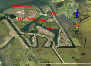
Apollo Beach Nature Preserve
6760 Surfside Boulevard
Apollo Beach, FL 33572
GPS 27° 47'25.16" N 82° 25'11.48" W
Apollo Beach Nature Preserve offers; Shoreline fishing, pavilions, beach, wildlife viewing and restrooms.
Ballast Point Park
5300 Interbay Boulevard
Tampa, FL 33611
GPS 27° 53'22.28" N 82° 28'55.95" W
( Entrance to park )
|
|
|
Ballast Point Park offers; Fishing pier, boat ramp, picnic pavilions, grills, playground, splash pad and restrooms.
Cotanchobee Fort Brooke Park
601 Old Water Street
Tampa, FL 33602
813-274-8615
GPS 27° 56'30.69" N 82° 27'05.07" W
|
|
|
Cotanchobee Fort Brooke Park offers; Fishing pier, jogging path, playground, hand launching of kayak and canoes and restrooms at the western end of the park near the street.
Cypress Point Park
5620 West Cypress Street
Tampa, FL 33607
Hours; Sunrise to Sunset
Gated
GPS 27° 57'04.32" N 82° 32'32.62" W ( Entrance )
|
|
|
Cypress Point Park offers; Shoreline fishing with respect to swimmers, rinsing showers, picnic pavilions, 18 hole disc golf course with a length of 7,980', playground and restrooms.
Desoto Park
2617 Corrine Street
Tampa, FL 33605
GPS 27° 56'53.88" N 82° 25'42.04" W ( Entrance )
|
|
|
Desoto Park located along McKay Bay offers; Shoreline fishing, a pier like structure, swingsets & restrooms.
E.G. Simmons Park 2401 19th Avenue Northwest
Ruskin, FL 33570
Hours: Spring/Summer 7 a.m. - 7 p.m., Fall/Winter 7 a.m. - 6 p.m.
Phone: 813-671-7655
GPS 27° 44'45.69" N 82° 28'25.12" W
( Waters edge at ramp )
Off of route 41 about 2 miles on 19th Avenue Northwest right hand turn boat ramp is about 1 mile further into the park.
GPS 27° 44'07.32" N 82° 27'50.82" W
( The right hand turn 2 miles from route 41 ~ entrance address also. )
|
|
|
E.G. Simons Park is 258 acres in size, with 200 additional acres set aside as a wildlife sanctuary. There are 87 individual campsites, and 1 group site. Campsites are, first come, first served. Fees do apply. The park has a fishing pier, shoreline fishing, boat ramp, playground, restrooms, potable water, camping, beach, sunbathing and swimming.
Entrance fees do apply to the park itself as well as use of the boat ramp. Annual passes are available.
Julian B. Lane Park
1001 North Boulevard
Tampa, FL 33606
GPS 27° 57'07.55" N 82° 28'02.63" W
Marjorie Park
115 Columbia Drive
Tampa, FL 33606
GPS 27° 56'00.07" N 82° 27'21.93" W
|
|
|
Marjorie Park is mostly dedicated to tennis courts (9), but you can fish from the shoreline here also.
Mosaic Park
6501 Riverview Drive
Riverview, FL 33534
GPS 27° 51'51.82" N 82° 23'00.72" W
Mosaic Park in Riverview, Florida offers; Shoreline fishing & 2 tennis courts, no other amenities at this location.
Picnic Island Park
404 Picnic Island Boulevard
Tampa, FL 33616
This address is in an industrial area. Follow Picnic Island Boulevard back to park area.
GPS 27° 51'29.59" N 82° 32'59.57" W
( Entrance to ramp and pier area )
|
|
|
Picnic Island Park offers; Boat ramp, fishing pier, hand launching kayaks and canoes, picnic pavilions, shoreline fishing, playgrounds, wildlife viewing and restrooms.
Mann-Wagnon Memorial Park
1101 East River Cove Street
Tampa, FL 33604
GPS 28° 01'11.43" N 82° 26'52.99" W
( Entrance )
NOAA
Mann-Wagnon Park offers;
Plant Park
River Crest Park
4802 North River Boulevard
Tampa, FL 33603
813-274-8615
GPS 27° 59'19.79" N 82° 28'03.56" W
( Intersection of Osborne Ave and North Blvd. small 3 car parking area )
GPS 27° 59'23.94" N 82° 27'56.40" W
( Intersection of N River Blvd and unnamed park access road ~ additional parking here )
NOAA
River Crest Park offers; Fishing piers ( 4 ), canoe / kayak launch, grills, picnic. The canoe / Kayak launch is on the northern side of the park. Fishing piers are on the southern side.
Ruskins Commongood Park
1st Avenue & 2nd Street Northwest
Ruskin, FL 33570
Ruskins Commongood Park offers; a fishing deck / dock, boat ramp & picnic pavilion. No restrooms at this location.
Upper Tampa Bay Regional Park
8001 Double Branch Road
Tampa, FL 33635
GPS 28° 01'18.94" N 82° 38'17.03" W
( Entrance )
Canoe launch.
Waterworks Park
1710 North Highland Avenue
Tampa, FL 33602
Williams Park
8749 US-41
Riverview, FL 33569
GPS 27° 51'36.47" N 82° 23'05.30" W
( Waters edge at ramp )
|
|
|
Williams Park offers; Boat ramp, courtesy docks, fishing pier, kayak launching, shoreline fishing, picnic pavilions, trash receptacles, picnic pavilions, playground, easy access to Hillsborough Bay & restrooms.
Useful Links
| County and City Parks in Hillsborough County Florida |
|
|
| Areas in Hillsborough County Florida include; Apollo Beach, Balm, Bloomingdale, Brandon, Carrollwood, Cheval, Citrus Park, Dover, East Lake-Orient Park, Egypt Lake-Leto, Fish Hawk, Gibsonton, Keystone, Lake Magdalene, Lutz, Mango, Northdale, Palm River- Clair Mel, Pebble Creek, Plant City, Progress Village, Riverview, Ruskin, Seffner, Sun City Center, Tampa, Temple Terrace, Thonotosassa, Town 'n' Country, University, Valrico, Westchase and Wimauma. |
| Areas of Salt and Brackish Water Hillsborough County Florida include; Alafia River, Bull Frog Creek, Broad Creek, Cockroach Bay, Coon Hammock Creek, Dick Creek, Double Branch Creek, East Bay, Garrison Channel, Hillsborough Bay, Hillsborough River, Little Manatee River, McKay Bay, Old Tampa Bay, Piney Point Creek, Rocky Creek, Ruskin Inlet, Seddon Channel, Sparkman Channel, Tampa Bay & Tampa Bay Channel. |
![]() Home
Home ![]() About
About ![]() Sitemap
Sitemap ![]() Credits
Credits
![]() Privacy
Privacy ![]() Advertise
Advertise ![]() Contact
Contact ![]()
