
Public
Boat Ramps
in
Brevard County, Florida
Seach our site below
Alex J. Goode Park Boat Ramp 1300 Northeast Bianca Drive
Palm Bay, FL 32910
GPS 28° 01' 47.24" N 80° 34' 58.12" W
( Waters edge at ramp )
Go to map of boat ramps in Brevard County
The Alex J. Goode Park boat ramp along Turkey Creek is operated by the City of Palm Bay and gives access to the Indian River Lagoon. Amenities include; single launching lane, courtesy docks, hand launching of kayaks and canoes, larger picnic pavilion, picnic tables and restrooms.
A fishing pier is on site also.


Ballard Park & Boat Ramp
 924 Thomas Barbour Drive
Melbourne, FL 32935
GPS 28° 07'31.02" N 80° 37'30.76" W
( Waters edge at ramp )
Go to map of boat ramps in Brevard County
|
|
Ballard Park sits on 10 acres along the Indian River and the Eau Gallie River in Melbourne, Florida. Amenities and activities at the park include; 4 launching lane boat ramp, courtesy docks, probably close to 50 boat trailer parking spots with the overflow area, shoreline fishing, pavilion, grills, tennis courts, playground and restrooms.


Christenson's Landing Public Boat Ramp 5355 US Highway 1
Grant ~ Valkaria, FL 32949
GPS 27° 55'52.26" N 80° 31'34.80" W
Go to map of boat ramps in
Brevard County
|
|
Christenson's Landing in Grant, Valkaria, Florida offers; 4 launching lanes, 44 paved boat trailer parking spaces, courtesy docks, hand launching and restrooms.

Claude Edge Front Street Park Boat Ramp
2210 Front Street
Melbourne, FL 32901
1-321-255-4608
( Leisure Services City of Melbourne )
GPS 28° 04'44.97" N 80° 36'02.31" W
( Entrance )
GPS 28° 04'46.99" N 80° 35'59.15" W
( Waters edge at ramp )
Go to map of boat ramps in Brevard County
|
|
Operated by the City of Melbourne the Claude Edge Front Street Park boat ramp is along the Indian River and offers; 2 wide launching lanes, courtesy docks, 40 paved boat trailer parking spaces, picnic area and restrooms. A fishing pier is on site also.


Constitutional Bicentennial Park Boat Ramp Closest intersection is:
West Cocoa Beach Causeway & West End Road
Cocoa Beach, FL 32920
Entrance to the ramp is 8/10ths of a mile west on West Cocoa Beach Causeway ( route 520 )
from the above intersection. Ramp is on the south side of the causeway
GPS 28° 21'27.36" N 80° 37'42.75" W
( Entrance )
Go to map of boat ramps in Brevard County
NOAA data is not reliable for this location.
The Constitutional Bicentennial Park boat ramp offers; Double wide ramp, access to the Banana River, courtesy docks, paved parking for about 25 trailers and port-o-lets.
Eddy Creek Boat Ramp ~ Primitive ~ Located within The Canaveral National Seashore
See video of the Eddy Creek boat ramp.
Eddy Creek offers; Parking for 7 boat trailers, 9 parking spaces for vehicles ( the beach access lot has an additional 29 spaces ) and the restrooms are located across the road, at base of stairs to the beach..
A fishing pier is on site also.
Eau Gallie Causeway Boat Ramp
 80 East Eau Gallie Boulevard ( SR-518 )
Melbourne, FL 32937
GPS 28°08'8.92"N 80°36'21.10"W
( Waters edge at ramp )
|
|
Go to map of boat ramps in Brevard County
The Eau Gallie Causeway boat ramp offers; 2 double wide ramps, parking for 40+/- trailers, courtesy docks, a couple of picnic tables at opposite ends of parking lot and port-o-lets.


Freddie Patrick Park Boat Ramp
Freddie Patrick Park offers; 8 launching lanes, 138 paved trailer parking spaces, courtesy docks, 2 small pavilions, washdown for boats, shoreline fishing, fish cleaning stations and restrooms.
John Jorgensen Landing Boat Ramp 5045 US Hwy 1
Grant, FL 32949
1-321-255-4400
Hours: Boat ramp is open 24 hours.
GPS 27° 56'14.95" N 80° 31'46.93" W
( Waters edge at ramp )
Go to map of boat ramps in Brevard County
NOAA not reliable
|
|
The John Jorgensen Landing boat ramp along the western shores of the Indian River in Grant, Florida offers; 2 single lane ramps, courtesy docks, parking for about 25 boat trailers, picnic table and port-o-lets.


Kars Park Hand Launch ~ Public can use the hand launch for a small fee payable at store
East Hall Road and Audobon Road
Merritt Island, FL 32953
1-321-867-7967
Open 9-5
GPS 28° 26'06.20" N 80° 39'35.20" W
( Waters edge at ramp )
|
|
Go to map of boat ramps in Brevard County
Kelly Park East & Boat Ramp 2550 North Banana River Drive
Merritt Island, FL 32952
1-321-455-1380
GPS 28° 24'07.70" N 80° 39'46.14" W
( Waters edge at ramp )
Hours:
7am - Dark
Ramp open 24 hours
|
|
Go to map of boat ramps in Brevard County
Video of the Kelly Park boat ramp.


Kennedy Point Park and Boat Launch 4915 South Washington Avenue
Titusville, FL 32780
1-321-264-5105
1-321-264-5037 ( Reservations )
Hours: 7am - Dark
Boat ramp is open 24 hours a day
GPS 28° 33'12.32" N 80° 47'42.18" W
( Waters edge at ramp )
|
|
See video of the Kennedy Point Park Boat Ramp.
Go to map of boat ramps in Brevard County
Kennedy Point Park is 5.3 acres in size and is along the Indian River in Titusville, Florida. The park offers; 2 lane boat ramp, courtesy dock, about 40 spots for boat trailer parking, picnic pavilion, grills, shoreline fishing along a paved walkway, restrooms and wildlife viewing.


Kiwanis Island Park Boat Ramp 951 Kiwanis Island Park Road
Merritt Island, FL 32954
1-321-455-1380
Hours: 7am - 8pm except for special uses
GPS 28° 21'26.96" N 80° 40'41.41" W
( Entrance )
GPS 28° 21'30.59" N 80° 40'42.30" W
( Waters edge at ramp )
NOAA not reliable
|
|
Kiwanis Island Park in Merritt Island Florida consists of 18.5 acres and has a tremendous amount to offer in a realtively small area. Activities and amenities at the park include; double wide boat ramp, courtesy docks, hand launching of kayaks and canoes, fishing, picnic pavilions, wildlife viewing, playground, exercise trail, drinking fountains, benches, ball fields, tennis courts and restrooms.


Lee Wenner Park and Boat Ramp 300 Riveredge Boulevard
Cocoa, FL 32922
1-321-633-1874
Hours: Ramp is open 24 hours
GPS 28° 21'18.98" N 80° 43'21.45" W
( Waters edge at ramp )
|
|
See video of the Lee Wenner Park boat ramp.
Go to map of boat ramps in Brevard County
Hours:
7am - Dark
Facilities reservations:
1-321-633-1874
Lee Wenner Park along the Indian River offers; 4 lane boat launch, courtesy docks, about 50 paved boat trailer parking spaces, pavilions, large grill at pavilion, picnic tables, restrooms, playground and "T" shaped dock are great for leisure inshore fishing.


Long Point Park Boat Ramp 700 Long Point Road
Melbourne Beach, FL 32951
GPS 27° 52'23.98" N 80° 28'16.58" W
( Waters edge at ramp )
|
|
Go to map of boat ramps in Brevard County


Manatee Cove Park & Hand Launching 4905 North Tropical Trail
Merritt Island, FL 32953
1-321-633-1874
GPS 28° 26'48.00" N 80° 43'14.37" W
( Hand launch area )
|
|
Go to map of boat ramps in Brevard County
Manatee Cove Park offers; Hand launching canoe or kayak and small fishing dock.
Marina Park Boat Ramp
501 Marina Road
Titusville, FL 32796
1-321-264-5105
GPS 28° 37'14.77" N 80° 48'40.75" W
( Entrance to boat ramp area off Marina Road)
GPS 28° 37'18.77" N 80° 48'35.57" W
( Waters edge at ramp )
See video of the Marina Park boat ramp.
NOAA
Titusville Marina Park sits on 20.3 acres along the Indian River. Amenities include; 3 boat ramp lanes open 24 hours, courtesy docks, 40 paved boat trailer parking spaces, shoreline fishing, picnic pavilions, playground, ball fields, skateboard park, wildlife viewing and restrooms.
McFarland Park & Small Boats Ramp 2060 Indian River Drive
Cocoa, FL 32922
Hours:
7am - Dark
GPS 28° 23'26.34" N 80° 44'28.78" W
( Waters edge at ramp )
|
|
Go to map of boat ramps in Brevard County
McFarland Park offers; Ramp for launching of small boats, 7 parking spaces, sheltered picnic area and fishing dock. No restrooms at this location.


Merritt Island National Wildlife Refuge Boat Ramps
 State Road 402 ( 5 miles east of Titusville )
Titusville, FL 32782
1-321-861-0667 ( General # )
1-321-861-0669 ( Visitors Center )
Hours:
Sunrise to Sunset
Fees:
No fees in general to get into refuge
Fees do apply at the boat ramps and
Black Point Wildlife Drive
Visitor Center Hours:
8:00am - 4:30pm Monday through Friday
9:00am - 5:00pm Saturday
BE SURE to get your self issued fishing permit prior to going fishing at MINWR ( Merrittt Island National Wildlife Refuge ). These are available through their website, at the kiosks on site and at the boat ramps themselves. Do not just put it in your pocket without signing ~ This is the way in which MINWR gets fishermen to understand that there are additional regulations that apply at this location
Launches from Kennedy Space Center will close portions of the refuge from time to time.
140,000 acres, established in 1963 as part of a buffer zone for NASA activities at The Kennedy Space Center
Beginning of the listings which are within the Merritt Island National Wildlife Refuge
Bairs Cove Boat Ramp Off of SR 3 on the
Merritt Island National Wildlife Refuge
GPS 28° 43'58.80" N 80° 45'24.97" W
( Waters edge at ramp )
Go to map of boat ramps in Brevard County
See video of the Bairs Cove boat ramp.


Beacon 42 Boat Ramp![]() 1.5 miles north of the Haulover Canal off
1.5 miles north of the Haulover Canal off
SR 3 ( West shore Mosquito Lagoon )
GPS 28° 45'22.52" N 80° 45'57.82" W
( Waters edge at ramp )
Go to map of boat ramps in Brevard County
See video of the Beacon 42 boat ramp.
The Beacon 42 ramp offers; About 30 spots for boat trailer parking. No courtesy docks or restrooms at this location.
Bio Lab Boat Ramp
On Merritt Island National Wildlife Refuge
Marguerite off of Courtenay Parkway North
GPS 28° 42'23.88" N 80° 43'15.04" W
( Waters edge at ramp )
The Bio Lab boat ramp on the Merritt Island Wildlife Refuge gives access to the Mosquito Lagoon and offers; single launching lane ramp, courtesy dock and parking for 25 +/-. No restrooms at this location.
See video of the Bio Lab boat ramp.
This video needs to be updated due to recent improvements at this location.
Go to map of boat ramps in Brevard County
WSEG Boat Ramp ~ Unimproved
GPS 28° 47'05.20" N 80° 47'15.46" W
( Intersection of access road and Rt 3 )
GPS 28° 47'23.71" N 80° 47'15.46" W
( Waters edge at ramp )
Located along the Mosquito lagoon within the Merritt Island National Wildlife Refuge the WSEG ramp is mostly used for hand launching of kayaks, canoes and small boats. Parking for about 5 trailers. No docks or restrooms at this location. Tiger Shoals would be about a 2 mile paddle to the northeast. This is considered a good area for trout and redfish.
End of the listings which are within the Merritt Island National Wildlife Refuge
Mims Launch ~ Natural Dirt 2010 Jones Avenue
Mims, Fl 32754
1-321-264-5105
Boat ramp is open 24 hours
GPS 28° 40'39.84" N 80° 49'35.26" W
( Waters edge at ramp )
|
|
Go to map of boat ramps in Brevard County
Mims launch is a .75 acre park offering a natural dirt ramp leading into the Indian River Lagoon, parking for about 10 trailers, shoreline fishing and wildlife viewing. The boat ramp is open 24 hours a day. No dock or restrooms at this location.


Parrish Park ~ Titusville On the A. Max Brewer Causeway
Titusville, FL 32796
1-321-264-5105
Hours:
7am - Dark
Boat ramp is open 24 hours a day.
GPS 28° 37'24.70" N 80° 47'43.40" W
( Waters edge at ramp )
|
|
Go to map of boat ramps in Brevard County
See video of the Parrish Park boat ramp.
Parrish Park is on SR-402 at the A. Max Brewer Causeway sitting on 36.6 acres the park offers;
6 launching lanes which are lighted, courtesy docks, 8 small picnic pavilions, canoeing, kayaking, fishing deck, 11 family picnic shelters, drinking fountain, restrooms, 46 car parking spaces, 47 boat trailer parking spaces, sunbathing and bird watching.
A
fishing pier is on site also.
Pineda Landing 5995 North US 1
Melbourne, FL 32940
1-321-255-4400
Hours: Boat ramp open 24 hours
GPS 28° 12'23.88" N 80° 39'41.34" W
( Waters edge at ramp )
|
|
Go to map of boat ramps in Brevard County
Located along the Indian River the Pineda Landing facility offers; 2 launching lanes, courtesy docks, probably parking about 45 boat trailers and restrooms.


Pollak Park Boat Ramp 1201 Main Street NE
Palm Bay, FL 32905
321-952-3443
GPS 28° 01'56.14" N 80° 34'57.86" W
( Waters edge at ramp )
|
|
Go to map of boat ramps in Brevard County
Pollak Park boat ramp is operated by the City of Palm Bay and offers; easy access to the Indian River Lagoon for smaller boats ( watch clearance of the railroad & US 1 bridges to the east ), restrooms, picnic pavilion, grills, playground and about 10 +/- designated boat trailer parking spaces.
You can also fish from the docks here with respect of boat launching and landing.


Port St John Boat Ramp 6650 North Cocoa Boulevard
Port St John, FL 32927
1-321-264-5105
Ramp open 24/7
Remainder of park open 7am - dark
GPS 28° 28'30.37" N 80° 45'59.61" W
( Waters edge at ramp )
|
|
See video of the Port St John boat ramp.
Go to map of boat ramps in Brevard County
The Port St John boat ramp sits on 1.17 acres and offers; 2 launching lanes, courtesy dock, parking for about 30 boat trailers. Fishing on the shoreline along with wildlife viewing are two main activities at this location. No rerstrooms at this location.


Rodney S. Ketcham Park 998 Mullet Road
Port Canaveral, FL 32920
GPS 28° 24'31.19" N 80° 37'52.08" W
( Waters edge at ramp )
|
|
Go to map of boat ramps in Brevard County
Rodney S. Ketcham Park offers; 2 launching lanes, courtesy docks, 28 paved boat trailer parking spaces, picnic pavilions, shoreline fishing and restrooms.
See video of the Rodney Ketcham Park boat ramp.


Ramp Road Park 528 Ramp Road
Cocoa Beach, FL 32931
GPS 28° 18'32.30" N 80° 36'50.96" W
( Waters edge at ramp )
|
|
Go to map of boat ramps in Brevard County
Ramp Road Park sits on 3 acres and offers; 2 launching lanes, picnic area, playground, fishing dock and restrooms. Very close to the Thousand Islands area, which has fabulous fishing.


Rodney Ketcham
998 Mullet Road
Port Canaveral, FL 32920
GPS 28° 24'31.19" N 80° 37'52.08" W
( Waters edge at ramp )
|
|
Go to map of boat ramps in Brevard County
Rodney Ketcham Park offers; 2 launching lanes, courtesy docks, 28 paved boat trailer parking spaces, picnic pavilions, shoreline fishing and restrooms. From this location it is about a 3.5 mile straight shot to the open Atlantic waters.
Scottsmoor Landing 2400 Huntington Avenue
Scottsmoor, FL 32754
1-321-264-5105
GPS 28° 46'13.58" N 80° 50'44.75" W
( Waters edge at ramp )
Go to map of boat ramps in Brevard County
The Scottsmoor Landing area sits on 3 acres along the Indian River Lagoon and offers. A boat ramp which is only suitable for boats less than 18 feet in length, shoreline fishing, wildlife viewing, picnic area, benches, port-o-lets and parking for about 15 vehicles with trailers and 19 car parking spaces.


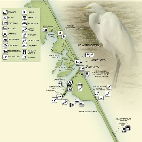
Sebastian Inlet State Recreation Area Boat Ramp 9700 South A1A
Melbourne Beach FL 32951
1-321-984-4852
Hours;
24 hours a day 365 days a year
Fees:
Call: 1-321-984-4852
GPS 27° 51'53.64" N 80° 27'03.44" W
( Entrance )
GPS 27° 51'01.48" N 80° 27'14.00" W
( Waters edge at ramp )
|
|
|
Go to map of boat ramps in Brevard County
Map of Sebastian Inlet State Park

Park is on both sides of the inlet
Sebastian Fishing Museum Hours
10:00am - 4:00pm 7 days a week
The ramp is technically in Indian River County, it is included here since the area spans the county line.
Additional small fees apply for use of the boat ramp at Sebastian Inlet State Recreation Area.
Sebastian Inlet State Recreation Area offers; 3 lane boat ramp, courtesy docks, parking for about 35-40 boat trailers, canoeing, kayaking, beaches, fishing, surf fishing, surfing, scuba diving, snorkeling, shelling, sunbathing, birding, camping, RV, fishing, treasure museums, picnic tables, picnic pavilions, showers day visitors, swimming, playground and restrooms.
There are both a fishing pier and jetty fishing at this facility also.
Indian River Lagoon on the western side and the Atlantic Ocean on the eastern.


1st Street Ramp 4727 1st Street
Grant, FL 32949
1-321-255-4400
Hours: Boat ramp is open 24 hours.
GPS 27° 55'45.05" N 80° 31'30.98" W
( Waters edge at ramp )
|
|
|
Go to map of boat ramps in Brevard County
The First Street ramp offers; Single launching lane, courtesy dock and parking for about 6 boat trailers. Launch your kayak or canoe here. No restrooms at this location.

6th Street Ramp
Closest intersection is;
6th Street & Pine Street
Melbourne Beach, FL 32951
GPS 28° 03'45.17" N 80° 33'49.87" W
( Waters edge at ramp )
The 6th Street ramp is operated by the City of Melbourne Beach and offers;, single launching lane and very limited parking for boat trailers. No restrooms at this location. The access is narrow and you may have to back down about 220' to the ramp.
Useful Links
| Areas in Brevard County Florida include; Cape Canaveral, Cocoa, Cocoa Beach, Grant, Melbourne Beach, Palm shores, Merritt Island, Rockledge, Indian Harbor Beach, Titusville, Palm Bay, Malabar, Satellite Beach, Scottsmore, Pineda, Bonaventure, Georgiana and Port St. John |
| Bodies of brackish and saltwater in Brevard County Florida include; Atlantic Ocean, Banana Creek, Banana River, Black Point Creek, Boggy Pond, Broadaxe Creek, Buck Creek, Canaveral Barge Canal, Cow Pen Creek, Crane Creek, Cucumber Slough, Devils Elbow, Dummit Creek, Eau Gallie River, Eddy Creek, Flowing Well Creek, Gator Creek, Gator Hole, Hog Point Creek, Horse Creek, Houseboat Cut, Indian River Lagoon, Intracoastal Waterway, Marsh Bay Creek, Max Hoeck Creek, Moore Creek, Mosquito Lagoon, Mullet Creek, Pintail Creek, Puckett Creek, Roach Hole, Ross Creek, Sebastian Inlet, Seven Pines Creek, St Sebastian, Sykes Creek, Tea Creek and Turkey Creek. |
![]() Home
Home ![]() About
About ![]() Sitemap
Sitemap ![]() Credits
Credits
![]() Privacy
Privacy ![]() Advertise
Advertise ![]() Contact
Contact ![]()