Virginia Beach, Virginia ~ Boat Ramps
- National &
State Parks - County &
City Parks - Beaches
- Boat Ramps
- Fishing Piers
- Map for
this page - Explore
Adjoining Counties
Public Boat Ramps Hand Launches Near Virginia Beach, Virginia
Seach our site below
Back Bay Wildlife Refuge Hand Launch
4001 Sandpiper Road
Virginia Beach, VA 23456
757-426-7128
The above address is for False Cape State Park. Once inside the park the launch is 1.3 miles down Sandpiper Road.
GPS 36° 40'19.82" N 75° 54'59.85" W
( Launch )
| No Tide Stations Close By. |
The Back Bay Wildlife Refuge offers; modern hand launch out away from the shoreline.

Campbells Landing Hand Launch
Closest intersection is;
Campbells Landing Road & Morris Neck Road
Virginia Beach, Virginia 23457
Launch is about 1.25 miles down Campbells Landing Road from above intersection.
GPS 36° 36'24.60" N 75° 59'26.43" W
( Launch )
| No Tide Stations Close By. |
The Campbell's Landing hand launch area has no amenities. This is an end of road launch area. Watch high tides and parking here!

Drum Point
Closest intersection is;
Mill Landing Road & Stone Road
Virginia Beach, VA 23457
Ramp is about 8/10ths of a mile east on Mill Landing Road from above intersection.
GPS 36° 38'03.31" N 75° 59'32.20" W
( Ramp Area )
No NOAA tide stations nearby
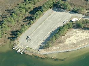
Operated by The Virginia Department of Game and Inland Fisheries (VDGIF) the Drum Point Boat ramp sits along the western shores of Back Bay and offers; single lane ramp, courtesy docks and parking for about 50 boat trailers in the lot across the street. No restrooms at this location.

First Landing State Park Boat Ramp Closest intersection is;
Atlantic Ave & 64th Street
Virginia Beach, VA 23451
From the above intersection head west on 64th Street into the cuddlesack and go onto paved roadway straight ahead, go approx. 2 miles back to the boat ramp area.
This area is totally separate from the main park areas near the beach.
GPS 36° 53'20.49" N 75° 59'25.79" W
( Entrance at end of 64th Street / Cuddlesack )
GPS 36° 53'31.84" N 76° 01'06.19" W
( Waters edge at ramp )
|
|
|
The First Landing State Park boat ramp area along Broad Bay offers; 4 launching lanes, courtesy docks, about 75 trailer parking spaces and restrooms.

Horn Point Hand Launch
Closest intersection is;
Horn Point Road & Muddy Creek Road
Virginia Beach, Virginia 23456
Launch is 8/10ths of a mile down Horn Point Road from above intersection.
GPS 36° 42'28.31" N 75° 58'12.65" W
( Launch )
No NOAA tide stations nearby
The Horn Point launch area sits along North Bay and is officially open April - October, from dawn - dusk. Restrooms are availble during those months and times.

Hutton Circle Hand Launch
Closest intersection is;
Oconee Avenue & Hutton Circle
Virginia Beach, VA 23454
Entrance is 400' down Hutton Cr from above.
GPS 36° 50'33.16" N 76° 03'23.83" W
( Area of parking )
GPS 36° 50'29.92" N 76° 03'24.53" W
( Launch )
NOAA Brown Cove, VA - Station ID: 8638922
The Hutton Circle hand launch sits along London Bridge Creek and offers; 2 official parking spaces and launching deck. It is about a 400' portage from parking to the deck.

Lafayette Park Boat Ramp
Closest intersection is;
La Valette and Columbus Avenue
Norfolk, Virginia 23504
Go 600' down La Valette, make first right continue 800' to the ramp area.
GPS 36° 52'51.03" N 76° 16'29.99" W
( Ramp )
NOAA Lafayette River, VA - Station ID: 8638671
The Lafayette Park Boat Ramp boat ramp offers single launching lane.

Lynnhaven Beach Boat Ramp 3576 Piedmont Circle
Virginia Beach, VA 23455
GPS 36° 54'24.98" N 76° 05'42.30" W
( Ramp )
NOAA VA. PILOTS DOCK, LYNNHAVEN INLET, VA - Station ID: 8638888
|
|
|
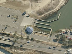
The Lynnhaven Beach boat ramp sits along the northern portion of the Lynnhaven River and offers; 4 launching lanes, courtesy docks, 82 trailer parking spaces and restrooms. This ramp gives easy access to the Lynnhaven Inlet and the open Atlantic waters. A fee is charged for launching here.

Munden Point
2001 Pefley Road
Virginia Beach, VA 23457
GPS 36° 34'56.55" N 76° 02'17.50" W
( Ramp )
No NOAA tide stations nearby
The Munden Point boat ramp sits along the North Landing River and offers 2 launching lanes, courtesy docks, 12 boat trailer parking spaces, picnicking, playground and restrooms. The ramp sits a short distance back on a canal which affords protection from cross currents and wind.

Owl Creek Municiple
717 General Booth Boulevard
Virginia Beach, VA 23451
757-385-1100
Open year round, 24 hours a day.
GPS 36° 49'21.99" N 75° 58'53.11" W
( Ramp )
NOAA Tides Rudee Inlet, VA - Station ID: 8639207
The Owl Creek Municiple Marina offers; 6 launching lanes, courtesy docks, 66 boat trailer parking spaces. Portable toilets are available.

Princess Anne Wildlife Management Area
Closest intersection is;
Back Bay Landing Road & Grimstead Road
Virginia Beach, Virginia 23457
8/10ths of a mile down Back Bay Landing Road from above intersection.
804-367-9587
Open year round, 24 hours a day.
GPS 36° 35'25.11" N 75° 59'31.44" W
( Ramp area )
No NOAA tide stations nearby
Operated by the Virginia Department of Game and Inland Fisheries the facility offers a single launching lane, 25-30 boat trailer parking spaces. The ramp sits about ¾ mile back a canal.

Useful Links
| Virginia Saltwater Fishing Regulations | Safe Handling of Self Caught Seafood |
| Videos of Fishing Knots | |
| Seafood Recipes | Fish of the Atlantic |
| Public Boat Ramps & Hand Launches in Virginia Beach, Virginia | |
|
|
| Bodies of Brackish & Saltwater in Virginia Beach, Virginia Include; Ashville Bridge Creek, Atlantic Ocean, Back Bay, Beggars Bridge Creek, Blackwater Creek, Broad Bay, Buchannan Creek, Capsies Creek, Chesapeake Bay, Deal Creek, Desert Cove, Dix Creek, Eastern Branch Lynnhaven River, Hell Point Creek, Lake Rudee, Lake Wesley, Linkhorn Bay, Little Creek, Little Creek Channel, Little Neck Creek, London Bridge Creek, Long Creek, Lynnhaven Bay, Lynnhaven River, Mill Dam Creek, Nawney Creeks, North Bay, North Landing River, Pleasure House Creek, Pocaty River, Redhead Bay, Rudee Inlet, Sand Bay, Scopus Marsh, Shipps Bay, Thalia Creek, Western Branch Lynnhaven River, West Neck Creek and Wolfsnare Creek. |
![]() Home
Home
![]() About
About
![]() Sitemap
Sitemap
![]() Credits
Credits
![]() Privacy
Privacy
![]() Advertise
Advertise
![]() Contact
Contact
![]()
