
Public Boat Ramps
in
Levy County,
Cedar Key, Florida
Seach our site below
Bird Creek Park Boat Ramp
Very western end of CR 40
Yankeetown, FL 34498
352-486-5127
GPS 29° 00'04.73" N 82° 45'42.01" W
( Waters edge at ramp )
Go to Video of the Bird Creek Boat Ramp
Go to map of saltwater boat ramps Levy County
|
|
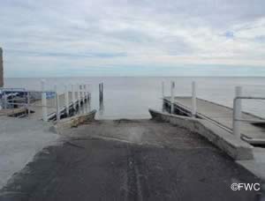
The Bird Creek Park boat ramp along the Withlacoochee River in Yankeetown Florida offers; 2 launching lanes, courtesy docks, portolets, 3 small picnic pavilions & parking for about 75+/- trailers depending on the way parking occurs along the shoulder. This ramp gives super easy access to the Gulf of Mexico.
Cedar Key Bridge 4 Boat Ramp Southwest 154 Avenue & Florida 24
Cedar Key, FL 32625
GPS 29° 09'51.59" N 83° 01'37.13" W
( Waters edge at ramp )
Go to video of the Bridge 4 Boat Ramp
Go to map of saltwater boat ramps Levy County
NOAA Cedar Key, FL 8727520


Cedar Key Marina ~ Gulf Side & Basin Side Boat Ramps Dock & A Streets
Cedar Key, FL 32625
GPS 29° 08'09.60" N 83° 01'48.00" W
( Waters edge at basin side ramp )
GPS 29° 08'08.94" N 83° 01'44.96" W
( Waters edge at gulf side ramp )
Go to Video of The Cedar Key Marina Boat Ramps
Go to map of saltwater boat ramps Levy County
NOAA Cedar Key, FL 8727520
|
|
The Cedar Key Marina boat ramp gulf side offers; 2 launching lanes & courtesy docks.
The Cedar Key Marina boat ramp basin side offers; 1 very wide launching lane & courtesy docks.
The bridge clearance at the far end of basin limits boats depending on tidal conditions.
The facility overall offers; 43 paved boat trailer parking spaces for both ramps & restrooms are on-site.
Launching fees are payable at the automated kiosks.


Fowlers Bluff Boat Ramp
Closest intersection is;
NW 152nd Avenue & NW 46th Lane
Chiefland, FL 32626
Ramp will be on your left 300' east on 46th Lane from above intersection.
GPS 29° 23'47.21" N 83° 01'33.82" W
( Waters edge at ramp )
The Fowlers Bluff ramp along the Suwannee River offers; single launching lane, picnicking, parking for about 6 boat trailers & portable restrooms.
Lower Suwanne Preserve South Entrance Boat Ramp
Closest intersection is;
Southwest Creek 347 & South Entrance Road
Cedar Key, FL 32625
Approxiametly 2 miles from the above intersection down South Entrance Road.
GPS 29° 17'25.85" N 83° 03'45.70" W
( Waters edge at ramp )
Go to map of saltwater boat ramps Levy County
NOAA Cedar Key, FL 8727520
|
|
Shell Mound Park Boat Ramp 17650 Southwest 78th Place
Cedar Key, FL 32625
GPS 29° 12'36.25" N 83° 03'47.92" W
( Waters edge at ramp )
Go to map of saltwater boat ramps Levy County
NOAA Cedar Key, FL 8727520
|
|
The Shell Mound Park boat ramp offers; 2 launching lanes with one of them having wooden skids for airboats, small courtesy dock, 20+ boat trailer parking spoaces & portable toilets are available.


Vassey Creek Boat Ramp Closest major intersection is;
Allen Park Road & State Highway 40A
Yankeetown, FL 34498
About 1.3 miles down Allen Park Road
from the above intersection.
GPS 29° 02'29.57" N 82° 44'15.51" W
( Waters edge at ramp )
Go to map of saltwater boat ramps Levy County
NOAA Florida Power, FL StationId: 8727386
|
|
The Vassey Creek ramp offers; single launching lane & parking for about 20 boat trailers. No other amenities at this location.
Waccasassa Park Boat Ramp
County Road 326 & 4 Court
Inglis, FL 32639
GPS 29° 12'49.32" N 82° 45'48.92" W
( Waters edge at ramp )
Go to map of saltwater boat ramps Levy County
NOAA Cedar Key 8727520
|
|
Technically a freshwater ramp that has easy access to brackish and saltwater fishing 2 - 3 miles down the Waccasassa River. Please be sure to have the appropriate license in hand for freshwater or saltwater. It may be best to purchase a combination license to stay on the safe side of the regulations.
Useful Links
| Public Boat Ramps in Levy County Florida |
|
|
| Areas in Levy County Florida include; Andrews, Bronson, Cedar Key, Chiefland, East Bronson, East Williston, Ellzey, Fowlers Bluff, Gulf Hammock, Inglis, Lebanon Junction, Manatee Road, Otter Creek, Raleigh, Rosewood, Turkeytown, Usher, Williston, Williston Highlands and Yankeetown. |
| Areas of Salt and Brackish Water Levy County Florida include; Gulf of Mexico, Suwannee River and Withlacoochee River. |
![]() Home
Home ![]() About
About ![]() Sitemap
Sitemap ![]() Credits
Credits
![]() Privacy
Privacy ![]() Advertise
Advertise ![]() Contact
Contact ![]()