Gloucester County, Virginia ~ Boat Ramps
- National &
State Parks - County &
City Parks - Boat Ramps
Gloucester - Fishing Piers
Gloucester - Map of
Boat Ramps - Boat Ramps
Adjoining Counties
Public Boat Ramps in Gloucester County, Virginia
Seach our site below
Cappahosic Landing Hand Launch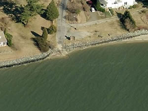 Closest intersection is;
Cappahosic Road & Allmondsville Road
Gloucester Point, Virginia 23062
Area is 650' down Cappahosic Road from above intersection.
GPS 37° 22'49.14" N 76° 38'08.48" W
( Launch area )
The Cappahosic Landing area is located along the York River and offers; Hand launching of kayaks or canoes, picnicking and portolets
( May thru October ).
Area is closed from 10pm-5am
The landings are maintained by VDOT
Cedar Bush ~ Oliver's Landing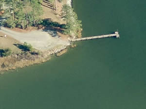 Closest intersection is;
Cedar Landing Road & Briggs Cove Road
Gloucester Point, Virginia 23062
Area is 800' down Cedar Landing Road from above intersection.
GPS 37° 18'40.14" N 76° 33'23.81" W
( Launch area )
The Cedar Landing area is located along the York River and offers; Hand launching of kayaks or canoes.
Area is closed from 10pm-5am
The landings are maintained by VDOT
Cherry Point Landing
Closest intersection is;
Broad Marsh Lane & Cherry Point Lane
Gloucester Point, Virginia 23062
Area is 4/10ths of a mile down Broad Marsh Lane from above intersection.
GPS 37° 17'13.97" N 76° 27'50.75" W
( Launch area )
The Cherry Point Landing area is located along the Severn River and offers; Hand launching of kayaks or canoes. No trailer launching available.
Area is closed from 10pm-5am
The landings are maintained by VDOT
Deep Point Landing Boat Ramp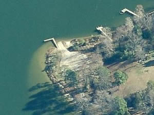 Closest intersection is;
Deep Point Lane & Wilson Farm Lane
Gloucester Point, Virginia 23062
Area 850' down Deep Point Lane from above intersection.
Landings Maintained by Virginia Game & Inland
Fisheries 804-367-1605
GPS 37° 32'09.90" N 76° 29'43.28" W
( Waters edge at ramp )
Deep Point Landing along the Piankatank River offers; single lane ramp, courtesy dock & picnicking.
The landings are maintained by Virginia Game & Inland
Fisheries 804-367-1605
Gloucester Beach Park Boat Ramp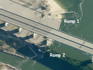 1255 Greate Road
Gloucester Point, VA 23062
The landings are maintained by Virginia Game & Inland
Fisheries 804-367-1605
GPS 37° 14'43.03" N 76° 30'14.32" W
( Ramp 1 )
GPS 37° 14'44.56" N 76° 30'17.75" W
( Ramp 2 )
The Gloucester Beach Park boat ramp offers; 2 separate launching areas, courtesy docks, 50 paved boat trailer parking spaces, pavilion, picnic tables, grills, playground and restrooms or portolets.
A fishing pier is on site also.
Guinea Landing Hand Launch
Closest intersection is;
Browns Bay Road & Guinea Circle
York, Virginia 23072
Go down Browns Bay Road 9/10ths of a mile from above intersection to the launching area.
Area is maintained by VDOT
GPS 37° 18'01.87" N 76° 24'13.64" W
( Launch )
The Guinea Landing hand launch is along Mobjack Bay.
No trailer access to the water.
Johns Point Landing Hand Launch
4351 Johns Point Road
Gloucester Courthouse, VA 23061
804-758-2321
GPS 37° 19'55.13" N 76° 26'41.70" W
( Launch )
Along the Free School Creek. Ample parking. No restrooms at this location.
There is also a fishing pier at this location.
Not on map.
Paynes Landing Hand Launch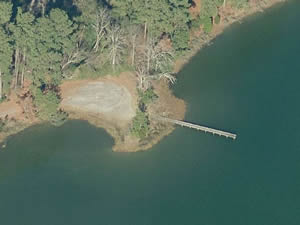 Closest intersection is;
Paynes Landing Road & Paige Road
Virginia, 23062
Go down Paynes Landing Road from above intersection for 1 mile to the area.
Area is maintained by Gloucester County
GPS 37° 22'08.88" N 76° 29'07.72" W
( Waters edge at ramp )
The Paynes Landing hand launch is along the Ware River.
No trailer access to the water.
Tanyard Landing Boat Ramp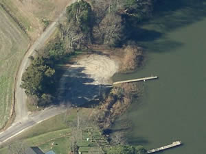 Closest intersection is;
Tanyard Landing Road & Red Bank Road
Virginia, 23062
Go down Tanyard Landing Road for 450' from above intersection to the area.
Maintained by Game and Inland Fisheries
GPS 37° 27'17.45" N 76° 40'04.84" W
( Waters edge at ramp )
The Tanyard Landing boat ramp is along the Poropotank River and offers; Single launching lane, courtesy dock & parking for about 10 boat trailers.
Warehouse Landing Boat Ramp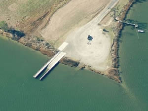 Closest intersection is;
Ware House Road & Fary Drive
Virginia 23061
Go down Ware House Road from above intersection for 1/3rd mile to the area.
Maintained by Game and Inland Fisheries
GPS 37° 24'11.39" N 76° 29'22.72" W
( Waters edge at ramp )
The Warehouse Landing boat ramp is along the Ware River and offers; Single launching lane, courtesy docks & parking for about 20-25 boat trailers.
Useful Links
| Virginia Saltwater Fishing Regulations | Safe Handling of Self Caught Seafood |
| Videos of Fishing Knots | |
| Seafood Recipes | Fish of the Atlantic |
| Boat Ramps & Hand Launches along Salt & Brackish in Gloucester County, Virginia |
| Areas in Gloucester County, Virginia Include; Achilles, Bellamy, Dutton, Freeport, Gloucester, Gloucester Point, Gumfork, Hayes, Maryus, Pampa, Perrin, Shacklefords, Sign Pine, Tidemill, Mattaponi, Ware Neck and Whitemarsh. |
| Bodies of Brackish & Saltwater in Gloucester County, Virginia Include; Back Creek, Bill Browns Creek, Blevins Creek, Browns Bay, Bryant Bay, Butler Creek, Carter Creek, Caucus Bay, Davis Creek, Elmington Creek, Free School Creek, Heywood Creek, Holy Bush Creek, John West Creek, Little Monday Creek, Long Creek, Morris Bay, North River, Old House Creek, Piankatank River, Perrin River, Poropotank River, Rowens Creek, Sarah Creek, Severn River, Thomas Creek, Thorntons Creek, Timberneck Creek, Vaughns Creek, Ware River, Whittaker Creek, Willetts Creek, Wilson Creek and York River. |
![]() Home
Home
![]() About
About
![]() Sitemap
Sitemap
![]() Credits
Credits
![]() Privacy
Privacy
![]() Advertise
Advertise
![]() Contact
Contact
![]()
