Accomack County, Virginia ~ Boat Ramps
- National &
State Parks - County &
City Parks - Beaches
- Boat Ramps
Hand Launches - Fishing Piers
Accomack - Map of
Boat Ramps - Boat Ramps
Adjoining Counties
Public Boat Ramps in Accomack County, Virginia
Seach our site below
Anns Cove Hand Launch
Closest intersection is;
New Road & Ann's Cove Road
Bloxom, Virginia 23308
From the above intersection go 2/10ths of a mile on New Road to the launch area.
GPS 37° 50'12.01" N 75° 40'26.19" W
( Ramp area )
Parking for about 6-8 vehicles ( please park respectfully. ) and no restrooms. Ramp is not in great shape. This area is used by local commercial fishermen.
Curtis Merritt Harbor Boat Ramp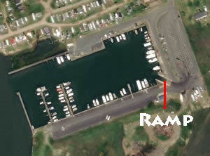 Closest intersection is;
Main Street & Curtis Merritt Harbor Drive
Chincoteague Island, Virginia 23336
Ramp is 700' down Curtis Merritt Harbor Drive from above intersection.
GPS 37° 54'09.48" N 75° 24'18.44" W
( Ramp area )
Located along The Canal just above Toms Cove the Curtis Merritt Harbor ramp offers; a single launching lane, floating courtesy dock, 39 trailer parking spaces and portable restrooms. There is also an elevated viwing platform along the waters edge with a picnic table. ( no shade structure on platform ).
|
|
|
Dix's Garagtha Landing Boat Ramp
29525 Gargatha Landing Road
Parksley, Virginia 23421
GPS 37° 46'30.13" N 75° 33'41.02" W
( Ramp area )
Located along Gargathy Creek the Dix's Landing ramp offers a single launching lane, courtesy docks, about 12 trailer parking spaces.
|
|
|
Chincoteague Veterans Memorial Park Boat Ramp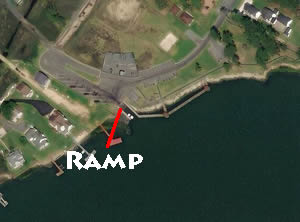 Closest intersection is;
Memorial Park Drive & Ridge Road
Chincoteague Island, Virginia 23336
900' on Memorial Park Drive from above intersection.
GPS 37° 54'59.17" N 75° 22'52.22" W
( Ramp area )
Located along Assateague Channel the Chincoteague Veterans Memorial Park boat ramp requires a permit and offers; single launching lane, courtesy docks, 11 paved trailer parking spaces, pavilion and portable restrooms. A fishing pier is on site also.
|
|
|
East Side Boat Ramp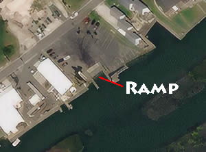 7620 East Side Road
Chincoteague Island, Virginia 23336
GPS 37° 55'04.01" N 75° 22'18.15" W
( Ramp area )
The East Side boat ramp on Chincoteague Island offers; Wide single launching lane, courtesy docks, 12 paved boat trailer parking spaces.
From Chicoteagues website 2018; "A fee of $20.00 is charged for a boat trailer decal valid from April 15 of each year to April 14 of the following year. A temporary pass valid for seven consecutive days is available for $5.00. The decal or pass may be purchased from the Town Office or the Curtis Merritt Harbor of Refuge. The Police Department also sells decals when the Town Office is closed; evenings, weekends and holidays."
|
|
|
Fir Landing Boat Ramp
Closest intersection is;
Fir Landing & Deep Hole Road
Chincoteague Island, Virginia 23336
700' on Fir Landing from above intersection
GPS 37° 56'08.45" N 75° 20'56.71" W
( Ramp area )
Along Little Oyster Bay, the Fir Landing Ramp requires a decal or pass which may be purchased from the Town Office, Police Department (outside Town Office hours and on weekends), or from the Harbormaster. The ramp offers a single launching lane, courtesy dock, no parking at this location, basically a neighborhood ramp.
|
|
|
Folly Creek Landing Boat Ramp
Closest intersection is;
Folly Creek Road & Custis Neck Road
Accomac, Virginia 23301
9/10ths of a mile on Folly Creek Road from above intersection
GPS 37° 41'38.45" N 75° 37'55.94" W
( Ramp area )
Along Folly Creek, the Folly Creek Landing Ramp offers a 2 launching lanes, non-floating courtesy dock and parking for 15-20 trailers. Unsure of restroom situation at this location.
Parking decals are required at this location click here for link to Accomacks County pay portal. Not all are required to pay the fee according to their page.
|
|
|
Greenbackville Harbor Boat Ramp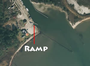 Closest intersection is;
Bayfront Street a& Harbor Drive
Greenbackville, Virginia 23356
Ramp area is 900' south on Harbor Drive from the above intersection.
No NOAA tide stations nearby.
GPS 38° 00'24.70" N 75° 23'24.37" W
( Waters edge at ramp )
The Greenbackville boat ramp along Chincoteague Bay offers; Wide single lane ramp, non-floating courtesy docks and parking for about 10 vehicles with trailers ( please respect parking near the business at the boat ramp area. ) Unsure of restroom situation here.
Hacks Neck Hand Launch
Closest intersection is;
Hacksneck Road & Killmon Lane
Hacksneck, Virginia 23358
From the above intersection go 3/10ths of a mile on Killmon Lane to the launch area.
GPS 37° 38'02.10" N 75° 52'51.90" W
( Launch area )
Limited parking and no restrooms.
Hammock Landing Boat Ramp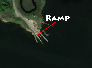 Closest intersection is;
Saxis Road & Route 788
Saxis, Virginia 23426
8/10ths of a mile on Route 788 from above intersection.
GPS 37° 54'13.56" N 75° 40'59.34" W
( Ramp area )
Along Messongo Creek Creek, the Hammock Landing Ramp offers single launching lane, courtesy docks, 15+/- trailer parking spaces.
|
|
|
Harborton Landing Boat Ramp
Closest intersection is;
Shore Drive & Harborton Road
Harborton, Virginia 23389
750' on Shore from above intersection
GPS 37° 39'58.68" N 75° 49'49.76" W
( Ramp area )
Along Pungoteague Creek, the Harborton Ramp offers 2 launching lanes, courtesy docks, about 30 designated trailer parking spaces and portable restrooms
|
|
|
Johnsons Wharf Boat Ramp
Closest intersection is;
Johnsons Landing Road & Hopkins Road
Parksley, Virginia 23421
7/10ths on Johnsons Landing Road from above intersection
GPS 37° 47'01.27" N 75° 42'06.80" W
( Ramp area )
Along Hunting Creek, the Johnsons Wharf Ramp offers 2 launching lanes, courtesy docks and about 5 trailer parking spaces.
|
|
|
Old NASA Dock Boat Ramp
At the intersection of;
Point Breeze Lane & Pierce Taylor Road
Hallwood, Virginia 23359
GPS 37° 50'34.09" N 75° 31'32.29" W
( Ramp area )
Located along Assawoman Creek the Old NASA Dock boat ramp offers a single launching lane, courtesy docks and about 10 trailer parking spaces.
|
|
This tide station is fairly far south |
Kegotank Landing Boat Ramp
Closest intersection is;
South Point & Kegotank Road
Bloxom, Virginia 23308
1/3rd mile on Kegotank Road from above intersection
GPS 37° 47'12.85" N 75° 33'42.90" W
( Ramp area )
The Kegotank Landing ramp is located along Gargathy Creek and offers a single launching lane, courtesy docks and about 10 trailer parking spaces.
|
|
|
Onancock Marina Boat Ramp-Closed for renovations
GPS 37° 42'42.08" N 75° 45'18.90" W
( Waters edge at ramp )
Queen Sound Landing Boat Ramp
Closest intersection from west is;
Chincoteague Road & Atlantic Road
Wallops Island, Virginia 23337
Approx 4.5 miles east on Chincoteague Road from above intersection, go around airport. will be on your right.
GPS 37° 56'05.10" N 75° 25'10.60" W
( Ramp area )
The Queen Sound Landing ramp is located along Route 175 and offers a single launching lane, courtesy docks and about 6-8 trailer parking spaces along the roadside.
|
|
|
Quinby Harbor Landing Boat Ramp
Closest intersection is;
Harbor Point Road & Radcliff Road
Quinby, Virginia 23423
275' down Harbor Point Road from above intersection
GPS 37° 32'57.82" N 75° 43'56.22" W
( Ramp area )
The Harbor Point Landing ramp is located along Upshur Bay and offers a single launching lane, courtesy docks and about 6-8 trailer parking spaces.
|
|
|
Saxis Landing Boat Ramp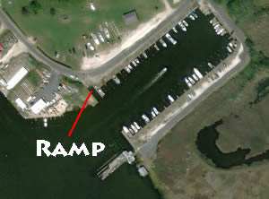 Closest intersection is;
Saxis Road & Mary's Drive
Saxis, Virginia 23427
Go 2/10ths of a mile on Saxis Road from above intersection, turn left onto last road before the water, ramp is straight ahead.
GPS 37° 55'08.24" N 75° 43'39.40" W
( Ramp area )
The Saxis Landing boat ramp is located along northern Pocomoke Sound and offers; Single launching lane, courtesy dock. Parking is limited at this location.
|
|
|
Schooner Bay Boat Ramp
Closest intersection is;
Bluebill Lane & Black Mallard Way
Onancock, Virginia 23417
1/3rd mile up Bluebill Lane from above intersection
GPS 37° 45'47.06" N 75° 46'21.90" W
( Ramp area )
The Schooner Bay boat ramp is located along Chesconessex Creek and offers a single launching lane, courtesy dock. Parking is limited at this location. No restrooms.
|
|
|
Southside Chesconessex Boat Ramp
Closest intersection is;
Southside Road & Plantation Road
Onancock, Virginia 23417
625' up Southside Road from above intersection
GPS 37° 44'53.85" N 75° 46'22.30" W
( Ramp area )
The Southside Chesconessex boat ramp is located along Chesconessex Creek and offers a single launching lane, courtesy dock. Not much parking at this location.
|
|
|
Town Dock Boat Ramp
Closest intersection is;
Main Street & Cropper Street
Chincoteague, VA 23336
The ramp area is across main street from above intersection.
NOAA
The Town Dock boat ramp is single lane, 14 parking spaces. No restrooms. A decal or pass may be purchased from the Town Office or the Curtis Merritt Harbor of Refuge. The Police Department also sells decals when the Town Office is closed; evenings, weekends and holidays. Note: Boat ramp / launch permits are for any use of the boat launch such as; boats, kayaks, canoes, paddleboards, etc.
GPS 37° 56'01.96" N 75° 22'45.00" W
( Ramp )
Wachapreague Town Marina Boat Ramp
Closest intersection is;
Atlantic Avenue & Custis Street
Wachapreague, Virginia 23480
275' up Atlantic Avenue from above intersection
GPS 37° 36'25.30" N 75° 41'12.97" W
( Ramp area )
The Wachapreague Town boat ramp is located along Wachapreague Channel and offers a single launching lane, courtesy docks and ample parking along the streets according to the Virginia Dept of Evironmental Quality. Please be aware of strong tidal currents at this location. This ramp gives easy access to Bradford Bay to the south and Burtons Bay to the north
|
|
|
Useful Links
| Virginia Saltwater Fishing Regulations | Safe Handling of Self Caught Seafood |
| Videos of Fishing Knots | Accomack Parking Decal Info |
| Seafood Recipes | Fish of the Atlantic |
| Public Boat Ramps in Accomack County, Virginia |
| Areas in Accomack County, Virginia Include; Atlantic, Belle Haven, Bloxom, Bobtown, Cashville, Centerville, Coocheyville, Craddockville, Crockett Town, East Point, Greenbackville, Greta, Hacksneck, Harborton, Hopeton, Horntown, Jenkins Bridge, Lecato, Leemont, Locustville, Macedonia, Mappsville, Mearsville, Melfa, Metompkin, Mutton Hunk, New Church, Onancock, Onley, Painter, Parksley, Pastoria, Pennyville, Quinby, Sanford, Sinnickson, Temperanceville, Tunnels Mill, Wachapreague, Wallops Island, Winterville, Wishart and Withams. |
| Bodies of Brackish & Saltwater in Accomack County, Virginia Include; Assateague Bay, Assawoman Creek, Atlantic Ocean, Back Creek, Bagwell Creek, Boggs Gut, Bogues Bay, Bordenstake Bay, Bradford Creek, Bull Cove, Bullbegger Creek, Bundick Creek, Burtons Bay, Cat Creek, Cattail Creek, Cedar Island Bay, Chesconessex Creek, Cherrytree Hill Bay, Chesapeake Bay, Chincoteague Bay, Clark Bay, Cockle Creek, Craddock Creek, Cross Creek, Curratuck Creek, Deep Creek, Doe Creek, Drum Bay, Finney Creek, Folly Creek, Fools Gut, France Creek, Gates Bay, Gargathy Bay, Garbathy Creek, Great Channel, Guilford Creek, Holdens Creek, Horseshoe Lead, Hunting Creek, Kegotank Bay, Little Back Creek, Longboat Creek, Machipongo River, Major Hole Bay, Matchotank Creek, Messongo Creek, Metompkin Bay, McLean Gut, Millstone Creek, Muddy Creek, Nandua Creek, Nickawampus Creek, Occohannock Creek, Onancock Creek, Oyster Bay, Pakers Creek, Parker Creek, Parting Creek, Pocomoke River, Pocomoke Sound, Pompco Creek, Powells Bay, Pungoteague Creek, Revel Creek, Robin Hood Bay, Ross Branch, Sandy Island Bay, Sandy Island Channel, Seal Creek, Shelly Bay, Shields Creek, Straight Creek, Swans Gut Creek, Swash Bay, Tar Bay, Tarkill Creek, Taylor Creek, Titlaw Creek, Underhill Creek, Upsur Bay, Wachapreague Channel, Watts Bay, Whites Creek, White Trout Creek, Warehouse Prong, Willis Creek, Wire Creek, Wire Passage and Young Creek. |
![]() Home
Home ![]() About
About ![]() Sitemap
Sitemap ![]() Credits
Credits ![]() Privacy
Privacy ![]() Advertise
Advertise ![]() Contact
Contact ![]()
