
Fishing Piers
in
Onslow County
North Carolina
Seach our site below
North Topsail Beach Park ~ Intercoastal Fishing Pier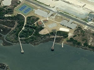 484 New River Inlet Road
North Topsail Beach, NC 28460
GPS 34° 29'51.16" N 77° 24'46.43" W
( Foot of pier )
NOAA New Topsail Inlet TEC2841
|
|
|
2 separate piers the one with the gazebo at the end is not for fishing. The fishing pier is about 130 in length over waters of a small alcove off of the ICW and has a couple of benches at the end. Restrooms, hand launching area, playground, basketball court and tennis courts. Beach access across the street.
Jacksonville Boat Ramp Fishing Dock 10 Tallman Street
Jacksonville, NC 28540
GPS 34° 45'06.38" N 77° 25'59.80" W
( Foot of pier )
NOAA New River Inlet, NC 8657167
|
|
|
The Jacksonville Boat Ramp Fishing Dock is 70' in length over the water. There is a boat ramp on site also.
L.P. Willingham Park Fishing Dock Closest intersection is;
Kerr Street & Freedom Trail
Jacksonville, NC 28540
GPS 34° 44'45.73" N 77° 26'11.91" W
( Foot of pier )
|
|
|
The L.P. Willingham Park Fishing Dock is 45' in length sitting parallel with shore, the pier runs about 25 off the shoreline. Very close to Kerr Street Park.
Sea View Ocean Fishing Pier 124 Fishing Pier Lane
North Topsail Beach, NC 28460
910-328-3172
GPS 34° 30'10.90" N 77° 23'47.41" W
( Foot of pier )
|
|
|
The Sea View Ocean Fishing Pier is 1000 feet in length over the Atlantic waters. A tackle shop and restrooms are available. Fishing reports for Sea View pier.
Sturgeon City Park Fishing Pier
Loyola Drive & Wardola
Jacksonville, NC 28540
GPS 34° 44'30.58" N 77° 25'47.48" W
( Foot of pier )
|
|
|
The Sturgeon City Park Fishing Pier is 100 feet in length over Wilson Bay. It's about a 1300' walk to the pier from the parking lot.
Wilson Bay Park Fishing Pier
5 West Bayshore Boulvevard
Jacksonville, NC 28540
910-938-5312
GPS 34° 44'32.42" N 77° 25'36.75" W
( Foot of pier )
|
|
|
The Wilson Bay Park Fishing Pier is 100 feet in length over Wilson Bay. There is also a wooden platform along the shoreline 300' in length. The park has picnic pavilion which holds 60 people, playground and restrooms.
Useful Links
| Public Fishing Piers in Onslow County North Carolina |
|
|
| Areas in Onslow County, North Carolina Include; Half Moon, Holly Ridge, Jacksonville, North Topsail Beach, Piney Green, Pumpkin Center, Richlands, Sneads Ferry and Swansboro. |
| Bodies of Brackish and Saltwater in Onslow County, North Carolina Include; Alligator Bay, Atlantic Ocean, Banks Channel, Bear Creek, Bear Inlet, Blue Creek, Brinson Creek, Browns Inlet, Bogue Inlet, Bogue Sound, Chadwick Bay, Chaney Creek, Charles Creek, Courthouse Bay, Cow Channel, Dicks Creek, Duck Creek, Edwards Creek, Ellis Cove, Everett Bay, Farnell Bay, Frenchs Creek, Fullard Creek, Goose Bay, Goose Creek, Hell Gate Creek, Holland Mill Creek, Howard Bay, Intercoastal Waterway, Mile Hammock Bay, Mill Creek, Morgan Bay, Mott Creek, New River, Northeast Creek, Queen Creek, Rogers Bay, Salliers Bay, Scales Creek, Shacklefoot Channel, Sneads Creek, Southwest Creek, Spicer Bay, Stones Bay, Stump Sound, Topsail Sound, Traps Bay, Wallace Creek, Ward Channel, Webb Creek, White Oak River and Wilson Bay. |
![]() Home
Home
![]() About
About
![]() Sitemap
Sitemap
![]() Credits
Credits
![]() Privacy
Privacy
![]() Advertise
Advertise
![]() Contact
Contact
![]()