
Boat Ramps
&
Hand Launches
in
Charlotte County, Florida
Seach our site below
Ainger Creek Park Boat Ramp 2011 Placida Road
Englewood, FL 34224
941-681-3742
GPS 26° 55'44.90" N 82° 20'09.88" W
( Entrance to park )
GPS 26° 55'48.60" N 82° 20'09.85" W
( Waters edge at ramp )
Go to map of boat ramps in Charlotte County
NOAA Englewood, Lemon Bay 8725747
|
|
Located on Ainger Creek in northern Charlotte County this ramp offers; Single launching lane, courtesy docks, Port-o-Lets, paved parking for about 25 boat trailers. Ainger Creek gives easy access to Lemon Bay, Manasota Key bay side and Oyster Creek. Gulf of Mexico fishing is easily accessible through Stump Pass to the south.
Species of fish that can be found around include; Red Fish ( Red Drum ), Snook, Spotted Sea Trout and Tarpon. Please be aware of the bridge height carrying route 775 over Ainger Creek, which I hear to be about 9 feet ( watch your tides ). Hand launch your canoe or kayak here also.


Allapatchee Shores Park Hand Launch 3100 Hickory Court
Punta Gorda, FL 33950
GPS 26° 53'11.42" N 82° 01'03.19" W
NOAA Punta Gorda 8725744
|
|
Butterford Boat Ramp 13555 Marathon Boulevard
Port Charlotte, FL 33981
1-941-473-1018
GPS 26° 54'58.75" N 82° 13'25.29" W
( Waters edge at ramp )
Go to map of boat ramps in Charlotte County
NOAA outside of locks


Darst Park Boat Ramp 537 Darst Avenue
Punta Gorda, FL 33950
GPS 26° 57'07.66" N 82° 00'35.39" W
( Waters edge at ramp )
Go to map of boat ramps in Charlotte County
NOAA Punta Gorda 8725744
|
|
The Darst boat ramp is along the Peace River in Punta Gorda and offers; single lane ramp, courtesy docks ( not very functional at low tides ), hand launching of kayaks and parking for 10-12 boat trailers depending on parking methods. From this location it is easy access to Coon Key, Bird Key and Long Island areas.


Deep Creek Park Boat Ramp ( Actually Desoto County Florida )
9695 Peace River Street
Arcadia, FL 34269
GPS 27° 03'38.46" N 82° 00'10.14" W
( Waters edge at ramp )
Go to map of boat ramps in Charlotte County
The Deep Creek boat ramp along the upper portions Peace River offers, Single lane ramp, parking for 30 boat trailers at the main park area, picnic pavilion and restrooms.
El Jobean Boat Ramp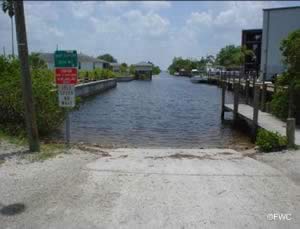 4224 El Jobean Road
Port Charlotte, FL 33953
941-625-7529
GPS 26° 58'06.44" N 82° 12'34.66" W
( Waters edge at ramp )
Go to map of boat ramps in Charlotte County
NOAA El Jobean, Myakka River 8725769
|
|
The El Jobean boat ramp offers; single launching lane, courtesy docks, easy access to the Myakka River through a short straight canal, 17 paved boat trailer parking and port-o-lets.
This park is a pay and display location, purchase a ticket at the kiosk and display on dashboard.


Harbour Heights Park Boat Ramp 27420 Voyageur Drive
Punta Gorda, FL 33983
1-941-627-1074
GPS 26° 59'24.45" N 81° 59'43.95" W
( Waters edge at ramp )
Go to map of boat ramps in Charlotte County
NOAA Punta Gorda 8725744
|
|
Harbour Heights Park in Punta Gorda sits along the Peace River at Whidden Bay and amenities include; Wide ramp with 2 launching lanes, courtesy docks, 13 paved boat trailer parking spaces, fishing, hand launching of canoes or kayaks, rentable pavilions, picnicking, grills, playground, volleyball courts, tennis courts & restrooms / port-o-lets.


Hathaway Park Boat Ramp 35461 Washington Loop Road
Punta Gorda, FL 33982
GPS 26° 58'28.51" N 81° 53'23.16" W
( Waters edge at ramp )
Go to map of boat ramps in Charlotte County
NOAA Punta Gorda 8725744
|
|
Hathaway Park sits along Shell Creek and offers; Single launching lane, courtesy dock, parking for about 22 boat trailers, hand launch kayak / canoe, large picnic pavilion, grills & restrooms.
Laishley Park Boat Ramp 100 Nesbit Street
Punta Gorda, FL 33950
GPS 26° 56'19.75" N 82° 03'06.17" W
( Waters edge at ramp )
Go to map of boat ramps in Charlotte County
NOAA Punta Gorda 8725744
|
|
Laishley Park operated by the City of Punta Gorda is located along the Peace River amenities include; 2 lane boat ramp, courtesy docks, 46 paved boat trailer parking spots at ramp area, picnic shelter with tables, walking paths, Veterans garden and restrooms. Fishing pier is on site also.
Ann Dever Memorial Regional Park ~ formerly known as;
Oyster Creek Regional Park Hand Launch ~ 2 totally sepearte entrances
GPS 26° 55'27.76" N 82° 19'55.92" W
( Western side entrance off Placida Road cloests to main pier and hand launch )
GPS 26° 55'14.95" N 82° 18'47.46" W
( Eastern side entrance off San Carlos Drive )
GPS 26° 55'25.35" N 82° 19'50.46" W
( Hand launch )
Kayaking access for the areas around Cedar Point Environmental Park. Oyster Creek and Lemon Bay.
Placida Boat Ramp Boca Grande Causeway & Gasparilla Road
Placida, FL 33946
GPS 26° 49'57.63" N 82° 16'10.45" W
( Waters edge at ramp )
GPS 26° 50'00.18" N 82° 16'08.54" W
( Boca Grande Causeway entrance is easiest if trailering a boat )
Go to map of boat ramps in Charlotte County
NOAA Placida, Gasparilla Sound 8725667
|
|
The Placida boat ramp offers; 3 launching lanes, courtesy docks, 75 boat trailer parking spaces & port-o-let. Easy access to Placida Harbor and the waters of the Gulf of Mexico.


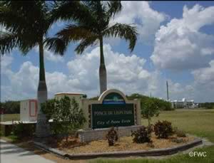
Ponce De Leon Park Boat Ramp
 Ponce de Leon Parkway and West Marion Avenue
Punta Gorda, FL 33950
Address does not populate well in all systems use GPS if possible.
GPS 26° 55'01.47" N 82° 05'25.29" W
( Entrance )
GPS 26° 54'33.52" N 82° 05'41.53" W
( Waters edge at ramp )
Go to map of boat ramps in Charlotte County
NOAA Punta Gorda 8725744
|
|
Ponce de Leon Park sits on 10 acres along Charlotte Harbor and offers; Single launching lane, courtesy dock, 10 paved boat trailer parking spaces, hand launching of kayaks or canoes, picnic pavilions, picnic tables, playground, scenic vistas, man made beach & restrooms.
Get information on the 2 Fishing piers on site also.


Port Charlotte Beach Park Boat Ramp 4500 Harbor Boulevard
Port Charlotte, FL 33952
941-327-7628
Parking fees apply at this park via a kiosk system.
GPS 26° 57'45.38" N 82° 06'49.93" W
( Waters edge at ramp )
Go to map of boat ramps in Charlotte County
NOAA Punta Gorda 8725744
|
|
The Port Charlotte Beach Park offers; 2 wide launching lanes, courtesy docks, 45 paved boat trailer parking spaces, hand launching of kayaks and canoes, fishing, pavilion rentals, grills, picnicking, playground & restrooms / port-o-lets.
Get information on the fishing pier on site also.


Riverside Park Boat Ramp 8320 Riverside Drive
Punta Gorda, FL 33982
GPS 26° 58'26.70" N 81° 57'56.14" W
( Waters edge at ramp )
Go to map of boat ramps in Charlotte County
NOAA Punta Gorda 8725744
|
|
The Riverside Park boat ramp sits along Shell Creek and offers; single lane launching ramp, parking for about 8 boat trailers, hand launching of kayaks & canoes, shoreline fishing and picnicking.
South Gulf Cove Boat Ramp 10150 Amicola Street
Port Charlotte, FL 33981
GPS 26° 52'55.01" N 82° 14'02.59" W
( Waters edge at ramp )
Go to map of boat ramps in Charlotte County
NOAA outside of the locks
South Gulf Cove Boat Ramp offers; Single lane ramp, courtesy dock, about 30 spaces for boat trailer parking, pavilions, playground and restrooms.
OPERATING THE SOUTH GULF COVE LOCK SYSTEM
THE SOUTH GULF COVE LOCK SYSTEM HAS BEEN AUTOMATED TO BE USED IN DIFFERENT WAYS:
1) At the end of the docks on the canal and bay sides there is a metal cabinet with chains and buttons (green and red). To operate just pull the chain and the lock will crack open, wait until the water has reached equal levels on both sides and pull the chain again and hold it down. The gates will open and you may enter the locks. Once inside, tie the boat and pull the chain in the middle of the lock next to the ladder and hold it down, gates will close behind and the other gate will crack open. wait until the water has equaled itself and then pull the chain and hold it down, gates will open completely and you may leave the locks. After exiting the locks, pull the chain at the end of the docks and hold it down until the locks are completely closed.
2) The green buttons on the cabinet at the end of the docks may be used instead of the chains. Press green button and hold it in and locks will start to operate same as using the chains. The red button if pressed will stop will stop the operation of the locks.
3) There are remote controls that may be used also: We are having problems with them, they time out after 20 seconds, you must press button on remote to continue operations
(Best to use chains or buttons when possible).


Spring Lake Park Boat Ramp 3520 Lakeview Boulevard
Port Charlotte, FL 33948
Ramp entrance is actually on Edgewater Drive
GPS 26° 58'26.10" N 82° 07'18.33" W
( Waters edge at ramp )
Go to map of boat ramps in Charlotte County
NOAA Punta Gorda 8725744
|
|
Bridge at Edgewater Drive has a clearance of approx. 10 feet depending on the tides.
Spring lake Park offers; Single launching lane, courtesy dock, 27 paved boat trailer parking spaces, canoe & kayak launching, a couple of fishing decks 1 with a shaded portion, nature preserve, nature & walking trail, picnicking & picnic tables and restrooms / port-o-lets.
Useful Links
|
|
| Areas in Charlotte County Florida Include; Boca Grande, Cape Haze, Charlotte Harbor, Charlotte Park, Cleveland, Deep Creek, Englewood, Grove City, Harbour Heights, Manasota Key, Murdock, Placida, Port Charlotte, Punta Gorda, Rotonda and Solana. |
| Areas of Salt and Brackish Water in Charlotte County Florida Include; Alligator Bay, Alligator Creek North Fork, Alligator Creek South Fork, Catfish Creek, Charlotte Harbor, Coral Creek, Deerfly Bay, Gasparilla Sound, Gulf of Mexico, Hunter Creek, Jim Long Lake, Lemon Bay, Little Alligator Creek, Muddy Cove, Myakka Cutoff, Myakka River, Peace River, Placida Harbor, Sam Knight Creek, Shell Creek, Tippecanoe Bay, Turtle Bay and Whidden Creek. |
![]() Home
Home ![]() About
About ![]() Sitemap
Sitemap ![]() Credits
Credits
![]() Privacy
Privacy ![]() Advertise
Advertise ![]() Contact
Contact ![]()