
Boat Ramps &
Hand Launches
in
Harford County, Maryland
Seach our site below
Flying Point Park Boat Launching Ramp
Closest intersection is;
Flying Point Road & Kennard Avenue
Edgewood, MD 21040
From the above intersection go 650' west on Kennard to the ramp area.
GPS 39° 26'32.69" N 76° 15'31.06" W
( waters edge at ramp )
|
|
|
The Flying Point Park boat launching ramp in the town of Edgewood, Maryland offers; 2 launching lanes, courtesy dock, paved parking for 31 trailers, additional parking for about 30 is in a grassed area adjacent to the lot, pavilions, grills, picnic areas, large playground & restrooms.
There is a fishing pier on site also.
This is the hours sign at front...are you confused yet?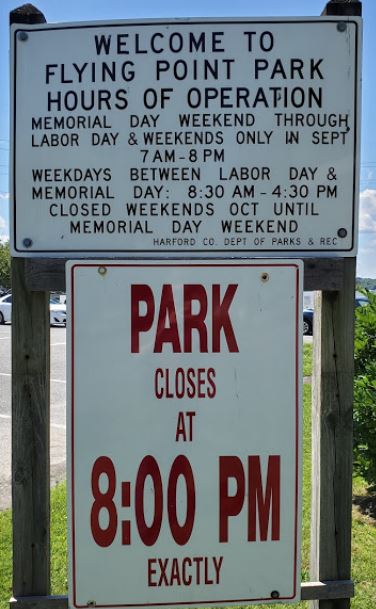
Jean Roberts Memorial Park Boat Launching Ramp
Closest intersection is;
Ostego Street & Water Street
Havre De Grace, MD 21078
Under the north end of the railroad bridge, really can't miss this.
GPS 39° 33'11.21" N 76° 05'27.13" W
( waters edge at ramp )
|
|
|
The Jean Roberts Memorial Park boat launching ramp in the town of Havre De Grace, Maryland offers; double wide launching lane, courtesy dock, paved parking for 10 trailers, small picnic area & seasonal portable restrooms.
A fishing deck is on site also
Mariner Point Park Boat Launching Ramp
Closest intersection is;
Kearney Drive & Latimer Road
Joppa, MD 21085
From the above intersection go 500' south on Kearney Drive to the ramp area.
GPS 39° 24'07.55" N 76° 21'05.24" W
( waters edge at ramp )
|
|
|
The Mariner Point Park boat launching ramp in Joppa, Maryland offers; 4 launching lanes, courtesy dock, paved parking for 60 trailers, picnic areas & restrooms.
Millard Tydings Memorial Park Boat Launching Ramp
Closest intersection is;
Strawberry Lane & Commerce Street
Havre De Grace, MD 21078
Entrance to the parking area at above intersection, ramp is at the far end of the lot
GPS 39° 32'15.72" N 76° 05'32.24" W
( waters edge at ramp )
|
|
|
The Millard Tydings Memorial Park boat launching ramp in the town of Havre De Grace, Maryland offers; double wide launching lane, courtesy dock, paved parking for 17 trailers, additional parking for about 40 is in a grassed area adjacent to the lot, picnic areas, large playground & restrooms.
Otter Point Boat Launching Ramp
Closest intersection is;
Otter Point Road & Leight Road
Abingdon, MD 21009
From the above intersection go 2/10ths of a mile down Otter Point Road to the ramp area.
GPS 39° 26'45.96" N 76° 15'59.28" W
( waters edge at ramp )
|
|
|
The Otter Point boat launching ramp in the town of Abingdon, Maryland offers; single launching lane, courtesy dock, paved parking for 12-14 trailers & portable restrooms.
Susquehanna State Park Boat Launching Ramp
Closest intersection is;
Stafford Road & Lapidum Road
Havre De Grace, MD 21078
Entrance to the parking area is at above intersection
GPS 39° 35'50.44" N 76° 07'38.96" W
( waters edge at ramp )
|
|
|
The Susquehanna State Park boat launching ramp along the Susquehanna River, north of Havre De Grace, Maryland offers; 2 launching lanes, courtesy dock, paved parking for 35 trailers, picnic areas & restrooms.
Willoughby Beach Boat Launching Ramp ~ Kennard Avenue
Closest intersection is;
Willoughby Beach Road & Kennard Avenue
Edgewood, MD 21040
From the above intersection go 2/10ths of a mile south on Kennard Avenue to the ramp area.
GPS 39° 26'06.34" N 76° 14'55.60" W
( waters edge at ramp )
|
|
|
The Willoughby Beach - Kennrd Avenue boat launching ramp in the town of Edgewood, Maryland offers; single lane, courtesy dock, paved parking for 20 trailers.
Useful Links
| Maryland Fishing Information | Safe Handling of Self Caught Seafood |
| Map of Boat Ramps & Hand Launches in Harford County in Maryland | |
| Videos of Fishing Knots | Seafood Recipes |
|
|
| Areas in Harford County Maryland Includes; Aberdeen, Belcamp, Edgewood, Havre De Grace, Joppa, Joppatowne, Perryman & Riverside. |
| Saltwater & Brackish Bodies of Water in Harford County Maryland Includes; Back Creek, Bush River, Chesapeake Bay, Church Creek, Delph Creek, Gunpowder River, Kings Creek, Lauderick Creek, Litle Romney Creek, Mosquito Creek, Romney Creek, Otter Point Creek, Spesutie Narrows, Susquehanna River, Swan Creek, Taylor Creek & Watson Creek. |
![]() Home
Home ![]() About
About ![]() Sitemap
Sitemap ![]() Credits
Credits
![]() Privacy
Privacy ![]() Advertise
Advertise ![]() Contact
Contact ![]()