Accomack County, Virginia ~ Fishing Piers
- National &
State Parks - County &
City Parks - Beaches
Accomack - Boat Ramps
Accomack - Fishing Piers
Accomack - Map of
Fishing Piers - Fishing Piers
Adjoining Counties
Public Fishing Piers in Accomack County, Virginia ~ Chincoteague & Saxis
Seach our site below
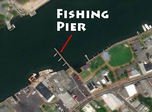
Chincoteague Island Fishing Pier at Waterfront Park Closest intersection is;
Church Street & Main Street
Chincoteague, VA 23336
Entrance to parking lot is at this intersection. The pier is at the southwest end of the park.
GPS 37° 56'04.02" N 75° 22'40.60" W
( Foot of pier )
|
|
|
The Chincoteague Island fishing pier is about 175' in length and is a popular area for fishing & crabbing. From the pier, visitors can view the drawbridge, commercial fishing boats & the downtown area.
The pier is located in downtown Chincoteague, close to the town's historic shopping district. Nearby are specialty stores and restaurants, a boat ramp, kayak and canoe launching area, pavillion and other amenities.
Once part of the old drawbridge, the fishing pier extends into Chincoteague's Main Channel, an important waterway for migrating fish. On the south side of the pier, several old bridge pilings remain, which provide structure. At night, lights on the pier attract crabs, baitfish, & gamefish.
Anglers fishing at this pier may catch flounder, striped bass, bluefish, black sea bass, gray trout, croaker, spot, kingfish, pigfish, northern puffer & blue crabs.
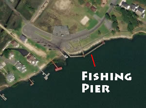
Chincoteague Veterans Memorial Park Fishing Pier Closest intersection is;
Memorial Park Drive & Ridge Road
Chincoteague Island, Virginia 23336
900' on Memorial Park Drive from above intersection.
GPS 37° 54'59.23" N 75° 22'50.50" W
( pier )
|
|
|
Located along Assateague Channel the Chincoteague Veterans Memorial Park fishing pier is 250' in length, sitting parallel with the shoreline about 25' out over the water. There are 2 shaded areas on the pier. Picnic pavilion and portable restrooms are available.
A boat ramp is on site also.
Deep Creek Dock
Closest intersection is;
Savage Lane & State Route 657
Deep Creek, Virginia, 23417
From the above intersection go 500' on State Route 657, dock is on the right.
GPS 37° 46'05.36" N 75° 44'59.58" W
( Foot of dock )
No restrooms at this location.
Not on navigation.
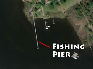
Hunting Creek Fishing Pier Closest intersection is;
Martz Road & Hopkins Road ( Route 669 )
Parksley, VA 23421
From the above intersection go 1/10th of a mile on Hopkins Road, pier area is on the left.
GPS 37° 47'22.63" N 75° 42'24.95" W
( Foot of pier )
|
|
|
The Hunting Creek fishing pier is about 400' in length with a 28' "T" at the end. Parking for about 4-5 cars. No restrooms at this location.
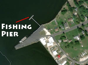
Saxis Fishing Pier Closest intersection is;
Lee's Circle & Saxis Road
Saxis, VA 23427
From the above intersection go 4/10ths of a mile on Saxis Road, pier will be on the right.
GPS 37° 55'14.39" N 75° 43'47.44" W
( Foot of pier )
|
|
|
The Saxis fishing pier is 200' in length with a 100' "T" at the end.The pier is handicapped accessible and ADA compliant. The pier is lit and is open 24 hours a day. There is no fee to use the pier and public parking is allowed along the seawall. However, a valid individual Saltwater Recreational Fishing License is required. Fish such as gray trout, croaker, spot , whiting, red drum, and striped bass can be caught at this site.
Useful Links
| Virginia Fishing Licenses Information | Safe Handling of Self Caught Seafood |
| Videos of Fishing Knots | |
| Seafood Recipes | Fish of the Atlantic |
| Public Fishing Piers in Accomack County, Virginia |
| Areas in Accomack County, Virginia Include; Atlantic, Belle Haven, Bloxom, Bobtown, Cashville, Centerville, Coocheyville, Craddockville, Crockett Town, East Point, Greenbackville, Greta, Hacksneck, Harborton, Hopeton, Horntown, Jenkins Bridge, Lecato, Leemont, Locustville, Macedonia, Mappsville, Mearsville, Melfa, Metompkin, Mutton Hunk, New Church, Onancock, Onley, Painter, Parksley, Pastoria, Pennyville, Quinby, Sanford, Sinnickson, Temperanceville, Tunnels Mill, Wachapreague, Wallops Island, Winterville, Wishart and Withams. |
| Bodies of Brackish & Saltwater in Accomack County, Virginia Include; Assateague Bay, Assawoman Creek, Atlantic Ocean, Back Creek, Bagwell Creek, Boggs Gut, Bogues Bay, Bordenstake Bay, Bradford Creek, Bull Cove, Bullbegger Creek, Bundick Creek, Burtons Bay, Cat Creek, Cattail Creek, Cedar Island Bay, Chesconessex Creek, Cherrytree Hill Bay, Chesapeake Bay, Chincoteague Bay, Clark Bay, Cockle Creek, Craddock Creek, Cross Creek, Curratuck Creek, Deep Creek, Doe Creek, Drum Bay, Finney Creek, Folly Creek, Fools Gut, France Creek, Gates Bay, Gargathy Bay, Garbathy Creek, Great Channel, Guilford Creek, Holdens Creek, Horseshoe Lead, Hunting Creek, Kegotank Bay, Little Back Creek, Longboat Creek, Machipongo River, Major Hole Bay, Matchotank Creek, Messongo Creek, Metompkin Bay, McLean Gut, Millstone Creek, Muddy Creek, Nandua Creek, Nickawampus Creek, Occohannock Creek, Onancock Creek, Oyster Bay, Pakers Creek, Parker Creek, Parting Creek, Pocomoke River, Pocomoke Sound, Pompco Creek, Powells Bay, Pungoteague Creek, Revel Creek, Robin Hood Bay, Ross Branch, Sandy Island Bay, Sandy Island Channel, Seal Creek, Shelly Bay, Shields Creek, Straight Creek, Swans Gut Creek, Swash Bay, Tar Bay, Tarkill Creek, Taylor Creek, Titlaw Creek, Underhill Creek, Upsur Bay, Wachapreague Channel, Watts Bay, Whites Creek, White Trout Creek, Warehouse Prong, Willis Creek, Wire Creek, Wire Passage and Young Creek. |
![]() Home
Home
![]() About
About
![]() Sitemap
Sitemap
![]() Credits
Credits
![]() Privacy
Privacy
![]() Advertise
Advertise
![]() Contact
Contact
![]()
