
Public
Boat Ramps
in
Volusia County, Florida
Seach our site below
Bethune Point Recreation Area Boat Ramp 100 East Bellevue Avenue
Daytona Beach, FL 32114
GPS 29° 12'00.29" N 81° 00'28.17" W
( Waters edge at ramp )
|
|
Go to map of saltwater boat ramps in Volusia County
Fishing pier on site also.
Go to Video of the Bethune Point Boat Ramp.
|
|


Cape Canaveral National Seashore Boat Ramp About ½ mile south of the intersection of;
Trout Avenue and Turtlemound Road
New Smyrna Beach, FL 32169
On Turtlemound Road
GPS 28° 56'12.47" N 80° 49'49.04" W
( Gate at entrance )
GPS 28° 56'05.19" N 80° 49'43.37" W
( Entrance to ramp area )
GPS 28° 56'03.64" N 80° 49'45.91" W
( Waters edge at ramp )
Once you go through the Apollo Beach Ranger gates the boat ramp is less than 2/10ths of a mile down on the right.
Go to map of boat ramps in Volusia County
The Cape Canaveral National Seashore boat ramp offers; single lane ramp, courtesy docks, restrooms and parking for 22 boat trailers.
Go to video of the Canaveral National Seashore boat ramp.


Cassen ~ Granada Riverfront Park Boat Ramp Granada Boulevard and Beach Street
Ormond Beach, FL 32175
GPS 29° 17'07.70" N 81° 03'15.55" W
( Waters edge at ramp )
|
|
Go to map of saltwater boat ramps in Volusia County
Cassen Park offers 2 separate launching lanes on the Halifax River, courtesy docks, a few picnic tables, about 25 boat trailer parking spaces and restrooms. A bait shop is also available.
There is a fishing pier on site also.
Go to video of the Cassen Boat Ramp.


City Island Park Boat Ramp East Orange Avenue and City Island Parkway
Daytona Beach, FL 32114
GPS 29° 12'33.51" N 81° 00'51.61" W
( Waters edge at ramp )
|
|
City Island Park boat ramp is a single lane with limited parking near ramp, no courtesy docks at this location.
George Kennedy Memorial Park Boat Ramp 103 North Riverside Drive
Edgewater, FL 32132
1-386-424-2485
GPS 28° 59'37.20" N 80° 54'12.83" W
( Waters edge at ramp )
|
|
Go to map of public boat ramps in Volusia County
George Kennedy Memorial Park in Edgewater offers; 4 launching lanes, 35 boat trailer parking spaces, fishing deck with gazebo, picnic pavilion and restrooms.
Go to video of the George Kennedy Memorial Park boat ramp.


Halifax Harbor Marina 450 Basin Street
Daytona Beach, FL 32114
1-386-671-3601
Marina Office Hours:
7:00 am - 6:00 pm Daily
GPS 29° 12'17.76" N 81° 00'44.32" W
( Waters edge at ramp )
|
|
Go to map of saltwater boat ramps in Volusia County
Halifax Harbor Marina offers; 8 launching lanes, courtesy docks, 32 boat trailer parking spaces and 50 vehicle spaces and restrooms. There is a fishing pier on site also
Go to video of the Halifax Harbor boat ramp.


High Bridge Park Boat Ramp 39 High Bridge Road
Ormond Beach, FL 32176
1-386-736-5953
Hours:
Sunrise to Sunset
Fees:
None
GPS 29° 24'30.35" N 81° 06'01.01" W
( Waters edge at ramp )
|
|
Go to map of saltwater boat ramps in Volusia County
Go to Video of the High Bridge Park Boat Ramp.
High Bridge Park in Ormond Beach offers; Single lane boat ramp, fishing pier under drawbridge, picnic tables, grills, pavilion, hand launching of kayaks or canoes and restrooms.
Launch your canoe or kayak with a fishing pole or two and work your way into Bulow Creek which is across the ICW, or just sit in the park and watch the boat traffic go by on the ICW.


Hiles Boat Ramp
156 Hiles Boulevard
New Smyrna, FL 32169
1-386-736-5953
GPS 28° 59' 19.02" N 80° 52' 13.84" W
( Waters edge at ramp )
Hiles along the ICW offers; Single lane ramp and hand launching. Launch your kayak or canoe here and paddle out towards Pine Island Bay & Brown's Bay.
No parking at this location.
Lighthouse Park Boat Ramp 4950 South Peninsula Drive
Ponce Inlet, FL 32127
GPS 29° 04'45.17" N 80° 55'42.80" W
( Waters edge at ramp )
|
|
Go to map of saltwater boat ramps in Volusia County
The Lighthouse Park boat ramp offers; 2 launching lanes, courtesy docks, 26 desiganted trailer spots in the lot east of the park accross the street & restrooms. This ramp gives super easy access to the Ponce De leon Inlet and the open Atlantic waters.
Go to video of the Lighthouse Park boat ramp.


Menard May Park Natural Small Boat ~ Hand Launch
 413 South Riverside Drive
Edgewater, FL 32132
GPS 28° 59'19.93" N 80° 54'03.22" W
( Waters edge at ramp )
|
|
Go to map of saltwater boat ramps in Volusia County
Fishing pier on site also.


North Causeway / Municiple Boat Ramp Complex of New Smyrna Beach ~ WEST and EAST Western Section Entrance
About 1/10 of a mile east on North Causeway from the intersection of:
North Causeway Drive and Quay Assisi
New Smyrna Beach, Fl 32169
On the opposite side of the road
Eastern Section Entrance
About 2/10 of a mile east on North Causeway from the intersection of:
North Causeway Drive and Quay Assisi
New Smyrna Beach, Fl 32169
On the opposite side of the road
GPS 29° 01'55.76" N 80° 54'59.34" W
( Waters edge at WEST ramp )
GPS 29°01'55.52"N 80°55'02.31"W
GPS 29° 01'57.04" N 80° 54'55.14" W
( Waters edge at EAST ramps )
|
|
Go to map of saltwater boat ramps in Volusia County
Western side amenities include; 2 lane boat ramp, courtesy docks, 64 boat trailer parking spaces, 20 vehicles, small picnic area, restrooms.
Eastern side amenities include; ( two ) 2 lane boat ramps, courtesy docks and about 25 boat trailer parking spaces.
Fishing pier at western side also.
Go to Video of the North Causeway Boat Ramp Complex.
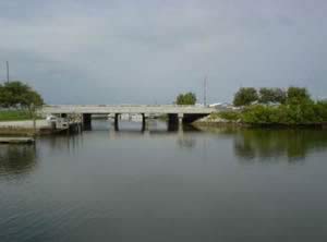


Port Orange Causeway Boat Ramps ( 3 ) 93 Dunlawton Ave
Port Orange, FL 32127
GPS 29° 08'51.00" N 80° 58'35.95" W
( Waters edge at ramp 1)
GPS 29° 08'51.59" N 80° 58'43.90" W
( Waters edge at ramp 2)
GPS 29° 08'43.05" N 80° 58'58.01" W
( Waters edge at ramp 3)
GPS for entrance heading westbound on
Dunlawton / North Ocean / 1A
29° 08'47.19" N 80° 58'47.33" W
GPS for entrance heading eastbound on
Dunlawton / North Ocean / 1A
29° 08'46.17" N 80° 58'46.67" W
Go to map of saltwater boat ramps in Volusia County
The Port Orange Causeway Park offers; 3 boat ramp areas, restrooms, picnic tables and grills, smaller covered pavilions, vehicle / boat parking and shade casted by the causeway bridge.
Fishing piers on site also.
Go to Video of the Port Orange Causeway Boat Ramps.


Riverfront Veterans Memorial Park 1933 South Palmetto Avenue
South Daytona, Fl 32119
1-386-322-3070
GPS 29° 10'33.69" N 81° 00'03.48" W
( Waters edge at ramp )
|
|
Go to map of saltwater boat ramps in Volusia County
Riverfront Veterans Memorial park offers; boat ramp, small fishing pier, kayak / canoe launch, picnic pavilions, grills and restrooms.
Go to Video of the Riverfront Veterans Memorial Boat Ramp.


Riverbreeze Park and Boat Launch 250 H.H. Burch Road
Oak Hill, Fl 32759
1-386-322-5133
GPS 28° 53'41.22" N 80° 51'13.12" W
( Entrance )
GPS 28° 53'54.83" N 80° 51'06.62" W
( Waters edge at ramp )
|
|
Go to map of saltwater boat ramps in Volusia County
Riverbreeze Park is operated by Volusia County and offers; 4 lane boat ramp, pavilions, shaded playground, benches and restrooms. There is a fishing pier on site also.
Parking for about 75 boat trailers.
Go to Video of the Riverbreeze Park Boat Ramp.


Sanchez Park and Boat Ramp Sanchez Avenue and Andrews Street
Ormond Beach, FL 32174
1-386-676-3250
Hours: Sunrise to Sunset
GPS 29° 17'51.50" N 81° 04'26.36" W
( Waters edge at ramp )
|
|
Go to map of saltwater boat ramps in Volusia County
On the banks of the Tomoka River, Sanchez Park is 8.4 acres in size and offers; boat ramp, picnic area, grills, playground and restrooms. There is a nice fishing dock along the Tomoka River on site also.
Go to Video of the Sanchez Park Boat Ramp.


Seabreeze Bridge Park and Boat Ramp 100 Seabreeze Boulevard
Daytona Beach, FL 32118
GPS 29° 14'00.33" N 81° 01'05.51" W
( Entrance )
GPS 29° 13'55.69" N 81° 01'12.97" W
( Waters edge at ramp )
|
|
Go to map of saltwater boat ramps in Volusia County
Seabreeze park on the Halifax River offers; 10 lane boat ramp and 20 boat trailer parking spaces.
No restrooms at this location.


Sunrise Park North Boat Ramp and Hand Launch
 11th Street and Riverside Drive
Holly Hill, FL 32117
GPS 29° 14' 50.53" N 81° 02' 10.52" W
( Waters edge at ramp )
|
|
9 paved boat trailer parking spaces. 3 fishing piers are on site also.
Go to Video of the Sunrise Park Boat Ramp ~ Hand Launch.


Swoope Boat Ramp
2495 North Dixie Highway
New Smyrna Beach, FL 32168
GPS 29° 03'52.60" N 80° 56'16.97" W
( Waters edge at ramp )
NOAA
Go to Video of the Swoope Boat Ramp
The Swoope boat ramp offers; a single wide ramp, courtesy docks, 76 paved boat trailer parking spaces and restrooms.
Tomoka Estates Boat Ramp 397 Palm Avenue
Ormond Beach, FL 32174
GPS 29° 18'51.08" N 81° 05'42.04" W
( Waters edge at ramp )
|
|
Go to map of saltwater boat ramps in Volusia County
Tomoka Estates boat ramp offers; boat ramp and parking for about 5 boat trailers. No restrooms at this location. This is NOT the ramp in the Tomoka State Park.


Tomoka State Park Boat Ramp ~ Hand Launch 2099 North Beach Street
Ormond Beach, FL 32174
GPS 29° 20'55.42" N 81° 05'19.58" W
( Waters edge at ramp )
GPS 29° 20'23.24" N 81° 04'60.00" W
( Entrance to the park )
|
|
Go to map of saltwater boat ramps in Volusia County
Go to Video of the Tomoka State Park Boat Ramp ~ Hand Launch.


Turtlemound Primitive Boat Ramp at Canaveral National Seashore
About 6.5 miles south of the intersection of; Trout Avenue and Turtlemound Road
New Smyrna Beach, FL 32169
On Turtlemound Road ( on right )
GPS 28° 56'12.47" N 80° 49'49.04" W
( Gate at north entrance to the park )
GPS 28° 51'27.66" N 80° 46'37.93" W
( Waters edge at ramp )
Go to map of saltwater boat ramps in Volusia County


Useful Links
| Public Boat Ramps in Volusia County, Daytona, Ponce Inlet, New Smyrna Beach, Florida |
| Areas in Volusia County Florida include; Daytona, Ormond by the Sea, Ormond Beach, Holly Hill, Daytona Beach, Daytona Beach Shores, Port Orange, Ponce Inlet, New Smyrna Beach, Edgewater, Deltona, Osteen, DeLand and Orange City. |
| Bodies of brackish and saltwater in Volusia County Florida include; Atlantic Ocean, Big Cove, Big Snapper Cut, Blind Spruce Creek, Botheration Creek, Bottle Island Creek, Browns Bay, Bulow Creek, Callalisa Creek, Canal Bradano, Canal Calore, Cedar Creek, Cook Creek, Dead End Creek, Elwinder Creek, Fox Slip, Gaines Slough, Halifax Canal, Halifax Creek, Halifax River, Hunter Creek, Indian River North, Inlet Creek, Intracoastal Waterway, Little Snapper Cut, Live Oak Creek, Lost Creek, Mill Creek, Mosquito Lagoon, Murray Creek, Orange Island Creek, Ponce de Leon Cut, Potts Creek, Rockhouse Creek, Rose Bay, Sheephead Cut, Shipyard Canal, Slippery Creek, Smyrna Creek, Snake Creek, Spruce Creek, Strickland Creek, Ten Mile Creek, Thompsons Creek, Tomoka Basin, Tomoka River, Turnbull Bay, Turnbull Creek, Turner Flats, Webster Creek and Wilbur Bay. |
![]() Home
Home
![]() About
About
![]() Sitemap
Sitemap
![]() Credits
Credits
![]() Privacy
Privacy
![]() Advertise
Advertise
![]() Contact
Contact
![]()