Sarasota County, Florida ~ County and City Parks
- National &
State Parks - County &
City Parks - Beaches
Sarasota - Boat Ramps
Sarasota - Fishing Piers
Sarasota - Map for
this page - Parks in
Adjoining Counties
Local Parks for Fishing in Sarasota County, Florida
Seach our site below
Bayfront Park
4052 Gulf of Mexico Drive
Longboat Key, FL 34228
GPS 27° 23'18.39" N 82° 38'26.26" W ( park entrance )
NOAA Sarasota 8726083
Parking, fishing

Bay Island Park 946 Siesta Drive
Sarasota, FL 34242
GPS 27° 18'08.71" N 82° 32'52.52" W
( Park entrance )
NOAA Sarasota 8726083
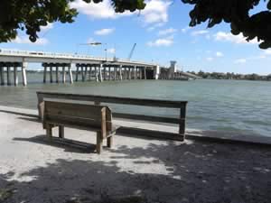
3 acres, fishing, benches, port-o-lets, scenery

Bird Key Park
200 John Ringling Causeway
Sarasota, FL 34236
GPS 27° 19'36.43" N 82° 33'43.58" W
( park entrance )
NOAA Sarasota 8726083
Sitting on 3 acres along Sarasota Bay Bird Key is owned by the City of Sarasota and maintained by Sarasota County. Bird Key Park offers; kayak & canoe launching, fishing, picnicking and swimming.

Causeway Park
420 John Ringling Boulevard
Sarasota, FL 34236
GPS 27° 20'03.42" N 82° 33'16.43" W ( foot of pier )
GPS 27° 20'08.94" N 82° 33'05.37" W ( entrance is off John Ringling south bound )
NOAA Sarasota 8726083
Get text on fishing pier page also

Centennial Park
1059 North Tamiami Trail
Sarasota, FL 34236
GPS 27° 20'45.33" N 82°32'54.47" W ( Waters edge at ramp )
GPS 27° 20'47.91" N 82°32'49.61" W ( Entrance to park )
NOAA Sarasota 8726083
Text here

Humphris Park
Closests intersection is;
Tarpon Center Drive and Inlet Circle
Venice, FL 34284
Park entrance is about 900 feet north on Tarpon Center from above intersection.
GPS 27° 06'44.13" N 82° 27'57.80" W ( Park entrance )
NOAA Venice, Roberts Bay 8725889
Get text

Indian Mound Park
210 Winson Avenue
Englewood, FL 34223
GPS 26° 57'28.56" N 82° 21'44.92" W ( Park entrance )
NOAA Englewood, Lemon Bay 8725747
Text here

Island Park
2 Marina Plaza
Sarasota, FL 34236
GPS 27° 19'57.15" N 82° 32'34.94" W ( Park entrance )
NOAA Sarasota 8726083
Get text ~ fountain, benches, fishing, boats, lots of activity

Ken Thompson Park
1700 Ken Thompson Parkway
Lido Key, FL 34236
GPS 27° 20'04.88" N 82° 34'32.77" W ( Entrance to park )
GPS 27° 20'01.17" N 82° 34'29.35" W ( Waters edge at ramp )
GPS 27° 20'12.04" N 82° 34'32.29" W ( Small fishing pier )
NOAA Sarasota 8726083
Text here

Lemon Bay Park
570 Bay Park Boulevard
Englewood, FL 34223
GPS 26° 58'18.91" N 82° 22'24.19" W ( Park entrance )
NOAA Englewood, Lemon Bay 8725747
Text here

Norsota Way Park
Siesta Drive and Norsota Way
Sarasota, FL 34277
GPS 27° 18'10.02" N 82° 32'52.66" W
NOAA Sarasota 8726083
North Jetty Park
¾ mile south from the intersection of;
Albee Road West and South Casey Key Road
Venice, FL 34275
GPS 27° 06'57.04" N 82° 28'01.72" W
( Entrance to park )
NOAA Venice, Roberts Bay 8725889
Phillippi Estate Park
5500 South Tamiami Trail
Sarasota, FL 34231
GPS 27° 16'11.88" N 82° 31'51.33" W ( park entrance )
NOAA Sarasota 8726083
Get text ~ Picnic pavilions, 2 fishing piers ( small ), kayak / canoe launching, fishing, restrooms

Pinecraft Park
1420 Gilbert Avenue
Sarasota, FL 34239
GPS 27° 19'15.28" N 82° 30'13.36" W ( park entrance )
NOAA Sarasota 8726083
Text here

Saphire Shores Park
Sun Circle and North Shore Drive
Sarasota, FL 34234
GPS 27° 22'40.69" N 82° 33'51.36" W
NOAA Sarasota 8726083
NO parking area, shoreline fishing.

Skip Sasko Park
2101 Scenic Drive
Venice, FL 34285
GPS 27° 04'18.96" N 82° 25'46.58" W
( Parking lot entrance )
NOAA

Whitaker Gateway Park
1455 North Tamiami Trail
Sarasota, FL 34230
GPS 27° 21'00.90" N 82° 32'49.47" W
( Entrance to park )
NOAA Sarasota 8726083
Restrooms, Playground, Picnicking, walking & fitness trail, fishing pier 80 feet in length.

| Florida Saltwater Fishing Regulations | Safe Handling of Self Caught Seafood |
| Saltwater Fish Species of Florida | |
| Videos of Fishing Knots | Seafood Recipes |
| Fishing Calendar for the Gulf of Mexico | |
| County & City Parks with Fishing in Sarasota County Florida |
|
|
| Areas in Sarasota County Florida Include; Bee Ridge, Desoto Lakes, Englewood, Fruitville, Gulf Gate Estates, Kensington Park, Lake Sarasota, Laurel, Longboat Key, Nokomis, North Port, North Sarasota, Osprey, Plantation, Ridge Wood Heights, Sarasota, Sarasota Springs, Siesta Key, South Gate Ridge, South Sarasota, South Venice, Southgate, The Meadows, Vamo Venice, Venice Gardens and Warm Mineral Springs. |
| Areas Brackish and Saltwater in Sarasota County Florida Include; Alligator Creek, Big Sarasota Pass, Big Slough, Blackburn Bay, Curry Creek, Deer Prairie Slough, Dona Bay, Dryman Bay, Forked Creek, Gulf of Mexico, Hudson Bayou, Intracoastal Waterway, Lemon Bay, Little Sarasota Bay, Lyons Bay, Myakka River, New Pass, Phillippi River, Roberts Bay, Salt Creek, Sarasota Bay and Whitaker Bayou. |
![]() Home
Home ![]() About
About ![]() Sitemap
Sitemap ![]() Credits
Credits
![]() Privacy
Privacy ![]() Advertise
Advertise ![]() Contact
Contact ![]()
