
Public
Fishing Piers
Docks and Bridges
in
Duval County, Florida
Seach our site below
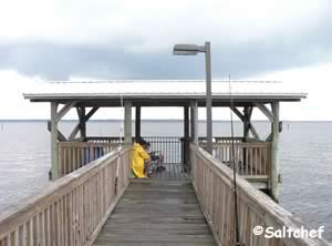
Arlington Lions Club Park Fishing Pier / Dock 4322 Richard D. Gatlin Road
Jacksonville, FL 32277
GPS 30° 22'41.88" N 81° 37'15.68" W
( Foot of pier / dock )
The Arlington Lions Club fishing pier is about 40' out over the water with a 35' "L" and offers; St Johns River fishing, picnic pavilions, playground and restrooms. A fishing license required here.
A boat ramp at this site also.
Go to: Video of the Arlington Lions Club Fishing Pier.


Bert Maxwell Fishing Pier 500 Maxwell Road
Jacksonville, FL 32218
GPS 30° 24'08.15" N 81° 39'49.84" W
( Foot of pier )
Go to map of fishing piers and bridges in Duval County
The fishing pier at Bert Maxwell is about 265 feet in length over the Trout River. The area offers; picnic pavilion, benches and restrooms.
A fishing license required here.
There is also a nice boat ramp at this location.
Go to: Video of the Bert Maxwell Fishing Pier.
|
|
|


Blue Cypress Preserve Park Fishing Pier 4012 University Boulevard North
Jacksonville, FL 32277
GPS 30° 22'26.66" N 81° 37' 00.32" W
( Foot of fishing pier )
GPS 30° 22'38.27" N 81° 36' 25.21" W
( Entrance to park off University Boulevard North )
Go to map of fishing piers and bridges in Duval County
Hours:
7:00am - 9:00pm
Fees:
None
Blue Cypress Preserve Park sitting on 119 acres offers; a fishing pier extending about 250 feet out over the waters of the St Johns River, shade structure at end of pier, picnic tables and 10 parking spaces at the pier area. The restrooms are up near the front of the park.
A fishing license required here.
There is a walkway along the shoreline connecting Blue Cypress Park to Arlington Lions Club Park.
|
|
|
Go to: Video of the Blue Cypress Preserve Fishing Pier.


Browns Creek Bridge Fishing
About 2 miles east on Heckscher Drive from 295 East
GPS 30° 25'02.74" N 81° 31'50.65" W
( Center of bridge )
Castaway Island Preserve Fishing Pier / Dock
Closest intersection is;
San Pablo Road South & Vanzile Avenue
Jacksonville, FL 32224
From the above intersection go north on San Pablo for 300' entrance will be on your right.
GPS 30° 17'46.58" N 81°26'15.95" W
( Entrance )
Go to: Video of the Castaway Island Preserve Fishing Pier / Dock.
Clapboard Creek Bridge Fishing
About 3.6 miles east on Heckscher Drive from 295 East
Near Palms Fish Camp
GPS 30° 24'19.02" N 81° 30'30.46" W
( Center of bridge )
County Dock Road Fishing Pier
Closed due to Hurricane Mathew
 Closest intersection is;
County Dock Road & Mandarin Road
Jacksonville, FL 32223
At the end of County Dock Road, limited parking.
GPS 30° 10'04.03" N 81° 38'51.64" W
( Foot of pier )
Go to map of saltwater fishing piers and bridges in Duval County
|
|
|
Fishing pier is about 525 feet in length over water, pavilions, restrooms, limited parking. The restrooms and pavilions are technically in Walter Jones Historic Park, but are close via a paved walking path. Wind surfers frequent this park also.
Fishing license required here.
Go to: Video of the County Dock Fishing Pier.


Dames Point Fishing Pier ~ El Faro Memorial 9101 Dames Point Road
Jacksonville, FL 32226
GPS 30° 23'16.30" N 81° 33'20.04" W
( Parking lot )
Go to map of fishing piers and bridges in Duval County
|
|
|
Dames Point Park and El Faro Memorial is 9 acres in size and is located on the banks of the St Johns River under the Dames Point Bridge on the northern side.
The park offers a fishing pier which is about 120 feet in length, pavilion, picnic tables and restrooms.
The access road to the park is pretty cool, as it goes between the concrete piers for the Dames Point Bridge.
Shade provided to various areas of the park by the bridge during the mid-day hours.
Fishing license required here.
Go to: Video of the Dames Point Fishing Pier.


Dutton Island Preserve Fishing Pier 793 Dutton Island Road West
Jacksonville, FL 32233
GPS 30° 20'25.08" N 81° 25'33.06" W
( Entrance area )
GPS 30° 20'29.47" N 81° 26'00.51" W
( Foot of the fishing pier )
Go to map of fishing piers and bridges in Duval County
Pier is on the northern end of the island and is about 150 feet in length over water, pier makes a bend and is mainly aligned with the shoreline. This is also considered the viewing pier.
Camping is $25.00 + tax per night and there is a $25.00 security deposit.
About 42 acres
1 Large pavilion and 3 smaller ones
47 car parking
Hand launch on site also.
|
|
|
Go to: Video of the Dutton Island Preserve Fishing Pier.


George Crady Fishing Bridge / Pier State Park 12157 Heckscher Drive
( Offices of Little Talbot Island Ranger Station )
Jacksonville, FL 32226
1-904-251-2320
Reasonable honor box fees apply at this location.
GPS 30° 30'35.96" N 81° 27'30.83" W
( Southern parking lot )
GPS 30° 31'28.33" N 81° 26'31.91" W
( Northern parking lot )
Go to map of fishing piers and bridges in Duval County
Audio brochure Little Talbot Islands State Park.
|
|
|
The George Crady bridge spans Nassau Sound.
Southern end is in Duval County, northern end in Nassau County ( best parking is on this end )
Open 24/7/365 for night fishing. Bring your bait or fish for it at the south end of the pier in the grass flats.
This is a long bridge, bring what ever you need the first time, use the restroom prior to going out, save a lengthy tripback, use a tackle cart to transport your fishing gear. Located 8 miles south of Fernandina Beach, 7 miles north of Little Talbot Island State Park.
4300 feet to the center of the main bridge from the southern lot, 2200 feet to the center of the main bridge from the northern lot, That can be alot of walking.
Species include: Whiting, Jacks, Drum, Tarpon, Redfish, Speckled Trout and some Flounder.
Fishing license required here.


Helen Cooper Floyd Park Pier Closest major intersection is;
A1A and Wonderwood Drive
Jacksonville, FL 32233
From the above intersection travel north on A1A for 1.3 miles, park entrance is on your left, entrance is not very obvious when driving due to the banking of the road. Please be careful of traffic coming south on A1A when turning into this park from this direction.
GPS 30° 22'52.43" N 81° 26'18.85" W
( Entrance off A1A )
GPS 30° 22'45.43" N 81° 26'39.39" W
( Foot of pier )
GPS 30° 22'52.78" N 81° 26'18.26" W
Go to map of fishing piers and bridges in Duval County
|
|
|
Go to: Video of the Helen Cooper Floyd Park Fishing Pier.


Jacksonville Beach Ocean Fishing Pier 503 1st Street North
Jacksonvillle Beach, FL 32250
1-904-241-1515
GPS 30° 17'35.70" N 81° 23'22.96" W
Go to map of fishing piers and bridges in Duval County
|
|
|
Hours:
6am - 10pm (December - March)
Fees:
Fishermen $4.00 3 rod maximum, carts may be used to transport tackle
Spectators $1.00
Children under 6 are free.
Restrooms, ADA accessible.
No Florida saltwater fishing license is required to fish on the pier, the pier purchases a license from the State of Florida that allows all fishing ticket purchasers to fish license free, this can be a very cost effective way for out of state persons to fish without having to purchase a moderately costly out of state fishing license.
No fly rods, hand lines, cast nets, pets or shark fishing on the pier.
Fish cleaning stations are available.
Small shade structures on the pier.
Pier is about 1300 feet in length.
Very cool Red Cross Building is close by. Check it out if your an architectural buff.
| Video of the Jacksonville Beach Fishing Pier. |
 |


Jim King Park Fishing Pier
8203 Heckscher Drive
Jacksonville, FL 32223
GPS 30° 23'51.26" N 81° 27'33.04" W
( Walkway to the pier on the backside of the Jim King boat ramp complex )
Go to: Video of the Jim King Park Fishing Pier.
Approximately 800 feet in length running parallel with the shoreline, the eastern portion is a floating dock.
Mandarin Park Fishing Pier 14780 Mandarin Road
Jacksonville, FL 32223
GPS 30° 08'01.52" N 81° 38'02.95" W
( Foot of the pier )
Go to map of fishing piers and bridges in Duval County
|
|
|
The Mandarin Park sits on close to 37 acres along Julington Creek. The fishing pier is 250 feet in length with a shade structure at the end. The park also offers; restrooms, pavilions, grills, playgrounds, benches and picnic tables.
A boat ramp is also on site.
Go to: Video of the Mandarin Park Fishing Pier.


Old Trout River Fishing Bridge
North Main Street ( Route 17 ) & Broward Road
Jacksonville, FL 32208
( closest intersection on north side of bridge )
GPS 30° 23'50.73" N 81° 38'56.19" W
( entrance road off of Route 17 / North Main Street )


Pumpkin Hill ~ Betz Tiger Preserve Fishing Pier
Closed due to Hurricane Mathew
 1.8 miles north on Pumpkin Hill Road
from the intersection of;
Pumpkin Hill Road & Cedar Point Road
Jacksonville, FL 32226
GPS 30° 29'12.34" N 81° 29'21.97" W
( Foot of pier )
NOAA Tiger Point, Pumpkin Hills Creek, FL 8720148
Pier is about 75 feet in length over the waters of the creek / marsh on the eastern side of Pumpkin Hill Road. The boundary lines of the parks here can be confusing and this pier is definetly closests to the Betz Tiger Preserve area.
Go to: Video of the Betz Tiger Preserve Fishing Pier.


Reddie Point Preserve Fishing Pier 4499 Yachtman Way
Jacksonville, FL 32277
GPS 30° 23'21.17" N 81° 37'10.48" W
( Foot of pier )
Go to map of fishing piers and bridges in Duval County
|
|
|
The Reddie Point Preserve pier is 650 feet in length over the southern side of the St Johns River. Benches are at the end of the pier for relaxing. Picnic tables are near the pier.
Go to: Video of the Rheddie Point Fishing Pier.


Riverview Park Fishing Pier 9620 East Water Street
Jacksonville, FL 32208
GPS 30° 24'48.86" N 81° 41'23.54" W
Go to: Video of the Riverview Park Fishing Pier.


Tide Views Preserve Fishing Pier 1 Begonia Street
Atlantic Beach, FL 32233
GPS 30° 19'31.39" N 81° 25'26.13" W
( Entrance to Preserve )
GPS 30° 19'33.27" N 81° 25'31.64" W
( Foot of pier )
|
|
|
Tide Views Preserve is operated by the City of Atlantic Beach. Pier is about 650 feet in length and is also the location of the kayak hand launch. Restrooms are at the front area of the park. It is approx. a 1400 foot walk to the end of the pier from the parking lot. Benches are at various locations along the trails.
Go to: Video of the Tide Views Preserve Fishing Pier.


Listings Below are in Clay County
Doctors Lake Park Fishing Pier ~ Clay County
2399 North Lakeshore Drive
Fleming Island, FL 32006
Hours; Sunrise to sunset
GPS 30° 06'54.27" N 81° 44'48.15" W
( Foot of pier )
Go to map of fishing piers and bridges in Duval County
Doctors Lake park offers a pier 320 feet in length on Doctors Inlet, picnic pavilion, grills, shade trees and ample parking.
|
|
|


Old Shands Bridge Fishing Pier ~ Clay County 4051 Old Shands Bridge Boat Launch
Green Cove Springs, FL 32043
Hours;
GPS 29° 58' 50.39" N 81° 38' 05.91" W
( Foot of pier )
There is also a boat ramp on site.
|
|
|
580 feet in length on the western shore of the St John's River. Pier is ligthed, benches, port-o-lets and small boat ramp on site also.


Governor's Creek ~ Small Fishing Pier ~ Clay County
1300 Orange Avenue
Green Cove Springs, FL 32043
GPS 30° 00' 26.34" N 81° 41' 30.02" W
( Foot of pier )
NOAA Red Bay Point, St Johns River, FL 8720503


Knight Fishing Pier ~ Clay County 1485 River Lane
Green Cove Springs, FL 32043
GPS 30° 02' 21.76" N 81° 42' 27.35" W
( Foot of pier )
NOAA Red Bay Point, St Johns River, FL 8720503
Pier is 250 feet in length with a 40 foot "T" at the end. Picnic pavilion and restrooms are on site, plenty of parking.
Boat ramp on site also.


Spring Park ~ Fishing Pier ~ Clay County Walnut Street and Magnolia Avenue
Green Cove Springs, FL 32043
GPS 29° 59' 39.24" N 81° 40' 34.57" W
( Foot of pier )
NOAA Red Bay Point, St Johns River, FL 8720503
The Spring Lake Park fishing pier in Green Cove Springs is 520 feet in length over the St Jpohns River and offers;, shaded portion midway out with benches, expansive playground, multiple picnic pavilions and restrooms.
Go to: Video of the Spring Park Fishing Pier.


Useful Links
| Fishing Piers & Bridges in Jacksonville Duval County Florida |
| Areas in Duval County, Florida Include; Atlantic Beach, Arlington, Baldwin, Englewood, Jacksonville, Jacksonville Beach, Mayport, Mandarin, Neptune Beach, Pecan Park and Mayport Naval Station. |
| Bodies of Salt and Brackish Water in Duval County, Florida Include; Arlington River, Atlantic Ocean, Big Pottsburg Creek, Back River, Big Fishweir Creek, Boathouse Creek, Broward River, Browns Creek, Burton Creek, Butcher Pen Creek, Caney Branch, Cedar Creek, Cedar Point Creek, Chicopit Bay, Christopher Creek, Clapboard Creek, Craig Creek, Dames Point Fulton Cutoff, Deep Creek, Deese Creek, Drummond Creek, Dunn Creek, Durbin Creek, Edwards Creek, Fishing Creek, Fitzpatrick Creek, Fort George River, Garden Creek, Goddby's Creek, Gunnison Cut, Hannah Mills Creek, Horseshoe Creek, Intracoastal Waterway, Julington Creek, Little Clapboard Creek, Little Pottsburg Creek, Mill Cove, Mill Creek, Miller Creek, Mink Creek, Moncrief Creek, Mud River, Nassau River, Nassau Sound, Nichols Creek, Ninemile River, Old Bull Bay, Ortega River, Pablo Creek, Plummers Cove, Pottsburg Creek, Pumpkin Hill Creek, Ribault River, Rushing Branch, Samples Creek, San Carlos Creek, Sawpit Creek, Seaton Creek, Shad Creek, Sherman Creek, Simpson Creek, Sisters Creek, St. Johns River, Strawberry Creek, Terrapin Creek, Thomas Creek, Trout River and Williamson Creek. |
![]() Home
Home
![]() About
About
![]() Sitemap
Sitemap
![]() Credits
Credits
![]() Privacy
Privacy
![]() Advertise
Advertise
![]() Contact
Contact
![]()